So a buddy of mine finally got an off road capable vehicle and we made our first trip. Spent far too long on Gaia and gravelmaps.com finding where we wanted to drive along but the trip was worth all the prep. Plan was to leave Mooresville ~8am and maybe make it to Blowing rock and turn around and find a place to camp. Turns out overlanding is slower than I'm used to driving the other mountain roads and we didnt quite make it lol. I'm also one that isn't much of a picture taker but I do have the tracks to share at the end and maybe my buddy has some to share.
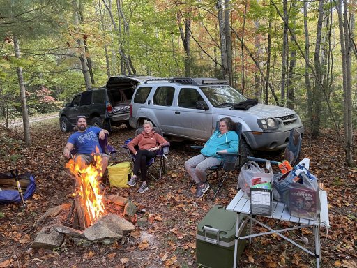
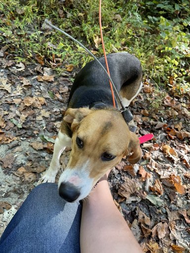
Trip started in Mooresville and took back roads through Lincolnton and Morganton and turned off 126 and started on Old 105 marking spots along the way to possibly come back to for the night. Turns out 105 is far more popular than I expected/remembered so while itll be nice to have those waypoints doubt very much we will ever be able to use them on any weekend trips. Planned to take a hike up to the Linville Falls but again it was far too overcrowded to bother and we left 105 for some asphalt and the Blue Ridge Parkway and did a little hike up to Flat Rock for some awesome views at almost 4100'. After that we turned off onto Roseboro Rd and followed that down Brown Mountain Beach Rd making a few stops here and there to see the water. Turned quickly onto asphalt again for a short bit and onto SR 1407/Maple Grove Church Road/Maple Sally. This road was amazing and well worth the trip. Tight and twisting up the side of the mountain with some awesome views and changing leaves, and we saw maybe 3 other people the whole time on it which was a nice change. About halfway up we ran across a young puppy that seemed lost, she had a Garmin GPS on her collar and a number we called. Scooped her up cause she was crying and super timid and scared and let them know where we were hoping to stop. Turns out she was a new hunting dog that got away 7 months old and hopefully she grows into her role but she didn't really seem to have the temperament for it. Once off Maple Sally we hit a forest service road a few miles in ran across a washed out land bridge and turned around to a super nice camping spot we passed and called it a day around 5:30. Had a fun night of roasted hotdogs and marshmallows and a few beverages. Got up in the morning and found a route around back to Globe road and into Blowing rock to finish off the trip and asphalt back home.
Overall it was a ton of fun and definitely headed back out soon, but going to do some cold weather gear purchases before the next one. If anyone is local to the area and can point us in another direction or share some tracks that would be amazing, next time I think we are just gonna do a little more exploring off different paths here and there that are open and see what we can find.
Also if anyone can give me some pointers on cleaning up the waypoints that would be great too!

 www.gaiagps.com
 www.gaiagps.com
Trip started in Mooresville and took back roads through Lincolnton and Morganton and turned off 126 and started on Old 105 marking spots along the way to possibly come back to for the night. Turns out 105 is far more popular than I expected/remembered so while itll be nice to have those waypoints doubt very much we will ever be able to use them on any weekend trips. Planned to take a hike up to the Linville Falls but again it was far too overcrowded to bother and we left 105 for some asphalt and the Blue Ridge Parkway and did a little hike up to Flat Rock for some awesome views at almost 4100'. After that we turned off onto Roseboro Rd and followed that down Brown Mountain Beach Rd making a few stops here and there to see the water. Turned quickly onto asphalt again for a short bit and onto SR 1407/Maple Grove Church Road/Maple Sally. This road was amazing and well worth the trip. Tight and twisting up the side of the mountain with some awesome views and changing leaves, and we saw maybe 3 other people the whole time on it which was a nice change. About halfway up we ran across a young puppy that seemed lost, she had a Garmin GPS on her collar and a number we called. Scooped her up cause she was crying and super timid and scared and let them know where we were hoping to stop. Turns out she was a new hunting dog that got away 7 months old and hopefully she grows into her role but she didn't really seem to have the temperament for it. Once off Maple Sally we hit a forest service road a few miles in ran across a washed out land bridge and turned around to a super nice camping spot we passed and called it a day around 5:30. Had a fun night of roasted hotdogs and marshmallows and a few beverages. Got up in the morning and found a route around back to Globe road and into Blowing rock to finish off the trip and asphalt back home.
Overall it was a ton of fun and definitely headed back out soon, but going to do some cold weather gear purchases before the next one. If anyone is local to the area and can point us in another direction or share some tracks that would be amazing, next time I think we are just gonna do a little more exploring off different paths here and there that are open and see what we can find.
Also if anyone can give me some pointers on cleaning up the waypoints that would be great too!