Creator III
- 6,480
- First Name
- Brandon
- Last Name
- Eberhardt
- Member #
20143
- Ham/GMRS Callsign
- KE0JBH
- Service Branch
- Air Force 02-18
A weekend meandering through the northern Cascade foothills just north of Chalan, near Twisp, Concully, and Omak
Creator III
20143

Enthusiast II
19767
Creator III
20143
No worries! Hope you have a blast! See you on the next oneI won't be able to make this trip. I am leaving that weekend for Yellowstone.
Creator III
20143

Enthusiast III
23620
Enthusiast II
6853

Explorer I
So far for those attending, how many think they'll be able to leave at noon Friday?
Enthusiast III
Pretty sure I can. I'll shoot for noon at the meet up. Looking forward to getting out again!So far for those attending, how many think they\'ll be able to leave at noon Friday?
Creator III
20143
It's definitely not private road, that I've verified. The signs we saw when we were there in April were not official, just looked like land owners trying to keep the traffic down. I called the ranger station and though they didn't have jurisdiction(I was checking on a couple other areas), they said they understood it was still a public road, and not officially closed to any traffic. I meant to call the sheriff's office to verify, but we had no issues with the 4 of us rolling through, we kept it speed down and limited dust (ie being as respectful as possible to the residents) but it's still on all mvum's I've seenNot likely I can do the whole weekend but may be able to do the Douglas Creek to Beebe Bridge section on Friday.
As an FYI I don't know if you have additional or more accurate information, but Chelan Hills Acres Rd, which terminates at Hwy 97, may be all private road. I was at that intersection today and there are signs there, which have been up for quite some time, stating that it is all private road and only property owners or guests are allowed through. I have heard from others that it is closed to the public and that the property owners are serious about protecting their space. Again, you may have information to the contrary.
An alternative route would be to go a bit further north and to come down McNeil Canyon Rd. It would be a few miles longer but intersects right at the Beebe Bridge river crossing.
Enthusiast II
6853
It's definitely not private road, that I've verified. The signs we saw when we were there in April were not official, just looked like land owners trying to keep the traffic down. I called the ranger station and though they didn't have jurisdiction(I was checking on a couple other areas), they said they understood it was still a public road, and not officially closed to any traffic. I meant to call the sheriff's office to verify, but we had no issues with the 4 of us rolling through, we kept it speed down and limited dust (ie being as respectful as possible to the residents) but it's still on all mvum's I've seenNot likely I can do the whole weekend but may be able to do the Douglas Creek to Beebe Bridge section on Friday.
As an FYI I don't know if you have additional or more accurate information, but Chelan Hills Acres Rd, which terminates at Hwy 97, may be all private road. I was at that intersection today and there are signs there, which have been up for quite some time, stating that it is all private road and only property owners or guests are allowed through. I have heard from others that it is closed to the public and that the property owners are serious about protecting their space. Again, you may have information to the contrary.
An alternative route would be to go a bit further north and to come down McNeil Canyon Rd. It would be a few miles longer but intersects right at the Beebe Bridge river crossing.
Enthusiast III
11737
So far for those attending, how many think they'll be able to leave at noon Friday?
Creator III
20143
Enthusiast III
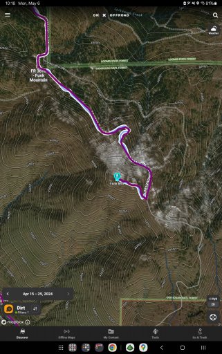
We might be OK by then...70's and 80's in Omak for the next few weeks is what I just looked up. I can bring wood, probably equal to about 2 1/2 bundles and some kindling.So looking at the recent imagery on OnX, snow levels are really good, looking like it's about 4500 ft, meaning to get to the very top of funk mountain we will encounter snow but it looks like it's only the last hundred yards or so. I'm going to plan on a solid attempt to summit, but know it may be shovel/ winch fest. Again it's only about a hundred yards it looks like so I don't think it'll be too bad. Worst case scenario we get out and walk.
Where we got stopped before on the scout was at 4000 ft and we may encounter some snow but I seriously doubt it will be more than a temporary impediment.
That being said, the next update for OnX recent imagery will be either the day we leave or after lol, so make sure you have downloaded the offline maps, and pack warm. I won't have my trailer, so won't have much room for wood (unless I can get my roof rack finished) so if anyone wants to stop by my place I can provide wood or please buy a bundle or two each if possible)
Enthusiast III
11737

Creator III
20143


Enthusiast III
11737
Weather looks good for the trip. Not too hot during the day, nice and cool at night.
Twisp is about 1200' lower than our planned camp for Friday, View attachment 278743View attachment 278744
Enthusiast III
11737
Creator III
20143
Creator III
20143
I haven't, to be honest. Since Nat isn't coming, I was going to keep my meals super simple. (I can't cook for shit... Put it this way, I could burn water )Have we figured out a Saturday pot luck theme?
Enthusiast III
I'm not a big fan of potlucks but if someone wants to head that up, I will gladly join in. I was just going to bring meals I had dehydrated for dinners.I haven't, to be honest. Since Nat isn't coming, I was going to keep my meals super simple. (I can't cook for shit... Put it this way, I could burn water )
That being said, if we keep it relatively simple, I'm game. Any ideas?