Daniel Boone Backcountry Byway (DBBB) Memorial Day weekend 2021

  • HTML tutorial

Advocate III

1,744
Yorktown, Indiana, United States
First Name
Jasen
Last Name
Ulmer
Member #

26569

Ham/GMRS Callsign
KD9HBC
I'm planning a 2-3 day trip on Memorial Day weekend. We're going to take our time and complete the whole loop. If anyone has any tips or pointers, it would be greatly appreciated. Also, if someone wants to join us, you're welcome to. Don't want too large of a group. We will be stopping/slowing down regularly to film.
 
Last edited:

SJ.Overland

Rank VII
Member

Trail Blazer I

6,140
Beavercreek, OH, USA
First Name
Shaun
Last Name
Johannes
Member #

15310

Ham/GMRS Callsign
KE8TDZ
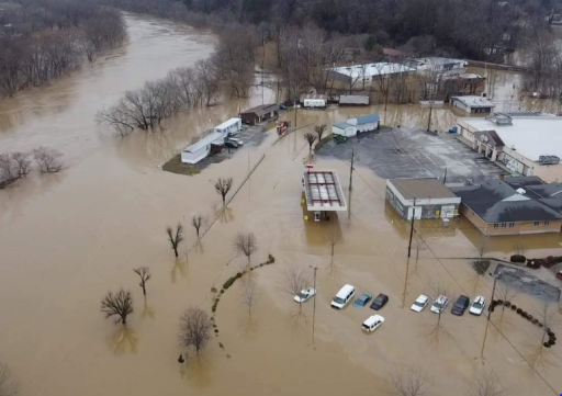
I am interested! I did this with some others on the forum but that was in December. Water at that time was higher than I've seen in some Videos. However with all the rain that area got this past week and the snow melt I'm betting the trail will be very different on the south side.


Drove through Beattyville in December and this photo was taken was this past weekend.
download (1)_Original.png
 
Last edited:

Advocate III

1,744
Yorktown, Indiana, United States
First Name
Jasen
Last Name
Ulmer
Member #

26569

Ham/GMRS Callsign
KD9HBC
I am interested! I did this with some others on the forum but that was in December. Water at that time was higher than I've seen in some Videos. However with all the rain that area got this past week and the snow melt I'm betting the trail will be very different on the south side.


Drove through Beattyville in December and this photo was taken was this past weekend.
View attachment 189823
I'll keep you posted, as the date gets closer. Plans aren't set in stone.
 
  • Like
Reactions: SJ.Overland

SJ.Overland

Rank VII
Member

Trail Blazer I

6,140
Beavercreek, OH, USA
First Name
Shaun
Last Name
Johannes
Member #

15310

Ham/GMRS Callsign
KE8TDZ
I'll keep you posted, as the date gets closer. Plans aren't set in stone.
Sounds good and Understood. Only portions I have no experience on are the southern most portion near Old Fincastle RD. Still fairly certain I can't do that portion with my Rig. And then the North West Portion after Spaas Creek Rd I've not seen either.
 

J.W.

Rank VI
Launch Member

Member III

3,432
Cincinnati
First Name
J
Last Name
W
Member #

17839

Plan on it being fairly crowded. Memorial Day weekend is always busy in the RR Gorge area and people have been locked up for 12 months.

Just a heads up.
 

SJ.Overland

Rank VII
Member

Trail Blazer I

6,140
Beavercreek, OH, USA
First Name
Shaun
Last Name
Johannes
Member #

15310

Ham/GMRS Callsign
KE8TDZ
Yeah I'm aware Federal Holidays are always a non-ideal time to camp. Dispersed camping isn't so bad typically but I expect a bunch of traffic this time. Not everyone is willing to winter camp :tearsofjoy:
 

Advocate III

1,744
Yorktown, Indiana, United States
First Name
Jasen
Last Name
Ulmer
Member #

26569

Ham/GMRS Callsign
KD9HBC
I'll keep you posted, as the date gets closer. Plans aren't set in stone.
Sounds good and Understood. Only portions I have no experience on are the southern most portion near Old Fincastle RD. Still fairly certain I can't do that portion with my Rig. And then the North West Portion after Spaas Creek Rd I've not seen either.
I'm going to give the rock obstacle a try. I've watched a lot of video of vehicles of all varieties make it. Seems like picking the right line is key. My YJ is a low CoG build,but I have taken it over some obstacles that, I thought for sure, I wouldn't make. By Memorial Day, I should have my highline fenders and sliders done.
 
  • Like
Reactions: SJ.Overland

Xterra19

Rank 0

Traveler I

60
Indianapolis, IN, USA
First Name
John
Last Name
Hurley
Hey all,

My buddies and I are planning a trip down to Kentucky to do some overlanding and camping in mid May on the DBBB. None of us have been out there before and were wondering what the best mapping app was for this route, and if there was any extra curveballs to expect. We've been doing a fair amount of research on youtube and forums but were looking for any additional tips or pointers that some of you may have. Just let me know in this thread.

Thanks!
 

SJ.Overland

Rank VII
Member

Trail Blazer I

6,140
Beavercreek, OH, USA
First Name
Shaun
Last Name
Johannes
Member #

15310

Ham/GMRS Callsign
KE8TDZ
Hey all,

My buddies and I are planning a trip down to Kentucky to do some overlanding and camping in mid May on the DBBB. None of us have been out there before and were wondering what the best mapping app was for this route, and if there was any extra curveballs to expect. We've been doing a fair amount of research on youtube and forums but were looking for any additional tips or pointers that some of you may have. Just let me know in this thread.

Thanks!
Well I guess the question is what do you already know about (in terms of the curveballs that is)? I can fill in what I know from there.
 
Last edited:

Xterra19

Rank 0

Traveler I

60
Indianapolis, IN, USA
First Name
John
Last Name
Hurley
Well I guess the question is what do you already know about (in terms of the curveballs that is)? I can fill in what I know from there.
We know the north end of the loop can get a little hairy with spaas creek and pumkin hollow, none the less we're up for the challenge. We all have 4wheel drive with decent ground clearance. We were hoping to get a better idea on the best places to start the loop (were thinking going through the nada tunnel and then working north on the east side of the loop first). We were also wondering if you have any good recommendations for camping grounds. We are shooting for public property, but are also willing to potentially pay for private property camp grounds. Also just curious of any legs of the loop that may pose a problem for us that time of year. Finally just from a navigation standpoint (what apps have worked best for you guys), we all haven't had much experience in the overlanding and were just curious what you guys have found works well. Any info helps!

Thank you!
 

SJ.Overland

Rank VII
Member

Trail Blazer I

6,140
Beavercreek, OH, USA
First Name
Shaun
Last Name
Johannes
Member #

15310

Ham/GMRS Callsign
KE8TDZ
We know the north end of the loop can get a little hairy with spaas creek and pumkin hollow, none the less we're up for the challenge. We all have 4wheel drive with decent ground clearance. We were hoping to get a better idea on the best places to start the loop (were thinking going through the nada tunnel and then working north on the east side of the loop first). We were also wondering if you have any good recommendations for camping grounds. We are shooting for public property, but are also willing to potentially pay for private property camp grounds. Also just curious of any legs of the loop that may pose a problem for us that time of year. Finally just from a navigation standpoint (what apps have worked best for you guys), we all haven't had much experience in the overlanding and were just curious what you guys have found works well. Any info helps!

Thank you!
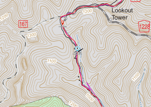
That is enough to go off of. Okay yeah Spaas creek has on particular section that looks way more difficult than it is. Heading Northbound it's about 1000 ft from the ending of Spaas Creek Rd coming up to June Bug. Looks like you have an Xtera so you should be fine. Mid-size trucks should also be fine. Fullsize is where things get hairy. Our buddy with the F-150 had maybe 1" on either side when going through this obstacle.
1615838607734.png


Beyond that I've not gotten around the other end yet on the North Trail as this section ate a lot of our daylight up. Plus it was at/near the winter solstice so we only had minimal daylight anyways.

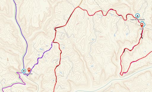
The southern side we avoided the area at Walker Creek and Old Fincastle Rd as there is a known rock shelf obstacle and with my tacoma being stock at the time I decided against trying it. From what I hear now though I may have been able to do it and should be extra fine now.
1615838884611.png

Those are the two Gotchas that I know about. As for camping spots we started in Slade at Koomer Ridge Campground for the first night as it's directly in the middle of the loop. There are dispersed sites on the northern end at Spaas creek road and they end right where it transitions to mainly dirt/trail. There are other areas for dispersed sites but you'll need to just look for them as best you can on the web as I don't have that info on me but I know they are out there.

For navigation I personally use Gaia and my Garmin Overlander. Both do things I like but you can get away with just one or the other. Gaia is better to plan with but in my experience the Overlander is better to navigate with when you're following a predefined route.

You can really start where ever you want but knowing what I know now I'd recommend starting at the Nada tunnel like you said and head east until you hit the track then head north.


*Edit it's also worth mentioning the southern side had a lot of flooding just recently. I would suspect a lot of the trail has been washed out or changed since i was there in December. I would take this into consideration until we get more info on the status. It was what they consider a 50-100 year flood depending on what area you look at.*
 

Advocate III

1,744
Yorktown, Indiana, United States
First Name
Jasen
Last Name
Ulmer
Member #

26569

Ham/GMRS Callsign
KD9HBC
We know the north end of the loop can get a little hairy with spaas creek and pumkin hollow, none the less we're up for the challenge. We all have 4wheel drive with decent ground clearance. We were hoping to get a better idea on the best places to start the loop (were thinking going through the nada tunnel and then working north on the east side of the loop first). We were also wondering if you have any good recommendations for camping grounds. We are shooting for public property, but are also willing to potentially pay for private property camp grounds. Also just curious of any legs of the loop that may pose a problem for us that time of year. Finally just from a navigation standpoint (what apps have worked best for you guys), we all haven't had much experience in the overlanding and were just curious what you guys have found works well. Any info helps!

Thank you!
That is enough to go off of. Okay yeah Spaas creek has on particular section that looks way more difficult than it is. Heading Northbound it's about 1000 ft from the ending of Spaas Creek Rd coming up to June Bug. Looks like you have an Xtera so you should be fine. Mid-size trucks should also be fine. Fullsize is where things get hairy. Our buddy with the F-150 had maybe 1" on either side when going through this obstacle.
View attachment 191264


Beyond that I've not gotten around the other end yet on the North Trail as this section ate a lot of our daylight up. Plus it was at/near the winter solstice so we only had minimal daylight anyways.

The southern side we avoided the area at Walker Creek and Old Fincastle Rd as there is a known rock shelf obstacle and with my tacoma being stock at the time I decided against trying it. From what I hear now though I may have been able to do it and should be extra fine now.
View attachment 191265

Those are the two Gotchas that I know about. As for camping spots we started in Slade at Koomer Ridge Campground for the first night as it's directly in the middle of the loop. There are dispersed sites on the northern end at Spaas creek road and they end right where it transitions to mainly dirt/trail. There are other areas for dispersed sites but you'll need to just look for them as best you can on the web as I don't have that info on me but I know they are out there.

For navigation I personally use Gaia and my Garmin Overlander. Both do things I like but you can get away with just one or the other. Gaia is better to plan with but in my experience the Overlander is better to navigate with when you're following a predefined route.

You can really start where ever you want but knowing what I know now I'd recommend starting at the Nada tunnel like you said and head east until you hit the track then head north.


*Edit it's also worth mentioning the southern side had a lot of flooding just recently. I would suspect a lot of the trail has been washed out or changed since i was there in December. I would take this into consideration until we get more info on the status. It was what they consider a 50-100 year flood depending on what area you look at.*
I use Gaia as well. It works cross-platform...

The South end is the only part of the route that I am concerned about. Walker Creek can apparently get pretty deep at times. You can always bypass areas that are too sketchy.
 
Last edited:
  • Like
Reactions: SJ.Overland

SJ.Overland

Rank VII
Member

Trail Blazer I

6,140
Beavercreek, OH, USA
First Name
Shaun
Last Name
Johannes
Member #

15310

Ham/GMRS Callsign
KE8TDZ
We know the north end of the loop can get a little hairy with spaas creek and pumkin hollow, none the less we're up for the challenge. We all have 4wheel drive with decent ground clearance. We were hoping to get a better idea on the best places to start the loop (were thinking going through the nada tunnel and then working north on the east side of the loop first). We were also wondering if you have any good recommendations for camping grounds. We are shooting for public property, but are also willing to potentially pay for private property camp grounds. Also just curious of any legs of the loop that may pose a problem for us that time of year. Finally just from a navigation standpoint (what apps have worked best for you guys), we all haven't had much experience in the overlanding and were just curious what you guys have found works well. Any info helps!

Thank you!
That is enough to go off of. Okay yeah Spaas creek has on particular section that looks way more difficult than it is. Heading Northbound it's about 1000 ft from the ending of Spaas Creek Rd coming up to June Bug. Looks like you have an Xtera so you should be fine. Mid-size trucks should also be fine. Fullsize is where things get hairy. Our buddy with the F-150 had maybe 1" on either side when going through this obstacle.
View attachment 191264


Beyond that I've not gotten around the other end yet on the North Trail as this section ate a lot of our daylight up. Plus it was at/near the winter solstice so we only had minimal daylight anyways.

The southern side we avoided the area at Walker Creek and Old Fincastle Rd as there is a known rock shelf obstacle and with my tacoma being stock at the time I decided against trying it. From what I hear now though I may have been able to do it and should be extra fine now.
View attachment 191265

Those are the two Gotchas that I know about. As for camping spots we started in Slade at Koomer Ridge Campground for the first night as it's directly in the middle of the loop. There are dispersed sites on the northern end at Spaas creek road and they end right where it transitions to mainly dirt/trail. There are other areas for dispersed sites but you'll need to just look for them as best you can on the web as I don't have that info on me but I know they are out there.

For navigation I personally use Gaia and my Garmin Overlander. Both do things I like but you can get away with just one or the other. Gaia is better to plan with but in my experience the Overlander is better to navigate with when you're following a predefined route.

You can really start where ever you want but knowing what I know now I'd recommend starting at the Nada tunnel like you said and head east until you hit the track then head north.


*Edit it's also worth mentioning the southern side had a lot of flooding just recently. I would suspect a lot of the trail has been washed out or changed since i was there in December. I would take this into consideration until we get more info on the status. It was what they consider a 50-100 year flood depending on what area you look at.*
I use Gaia as well. It works cross-platform...

The South end is the only part of the route that I am concerned about. Walker Creek can apparently get pretty deep at times. You can always bypass areas that are too sketchy.
Yep that’s what we did.
 

SJ.Overland

Rank VII
Member

Trail Blazer I

6,140
Beavercreek, OH, USA
First Name
Shaun
Last Name
Johannes
Member #

15310

Ham/GMRS Callsign
KE8TDZ
OK dates are set! MAY 27-31. We're planning on hitting the trail on the 28th (5 hour drive from Indiana). I think we're going to start in Slade and head through the tunnel, counter-clockwise on the loop.
Ok I will check my schedule. I’ll DM you on what’s up.
 

Advocate III

1,744
Yorktown, Indiana, United States
First Name
Jasen
Last Name
Ulmer
Member #

26569

Ham/GMRS Callsign
KD9HBC
OK dates are set! MAY 27-31. We're planning on hitting the trail on the 28th (5 hour drive from Indiana). I think we're going to start in Slade and head through the tunnel, counter-clockwise on the loop.
Ok I will check my schedule. I’ll DM you on what’s up.
Sounds good, looking forward to meeting you!
 
  • Like
Reactions: SJ.Overland

Advocate III

1,744
Yorktown, Indiana, United States
First Name
Jasen
Last Name
Ulmer
Member #

26569

Ham/GMRS Callsign
KD9HBC
Sounds good, looking forward to meeting you!
Same here! I'm hoping I can swing the trip. Should know here in a few days. I don't think I can take Friday off so I may need to join up on Friday evening.
We're not going to be moving fast. So, you should be fine. I'll let you know where we stop for the night.
 
  • Like
Reactions: SJ.Overland