Educator I
- 10,890
- First Name
- Jim
- Last Name
- Bro
- Member #
12989
- Service Branch
- USAF DAV
Now that is a great reply......Don't tease me, now! You're making me all tingly! :D
Educator I
12989
Now that is a great reply......Don't tease me, now! You're making me all tingly! :D
I'm looking for Western NC and East TN routes if anyone has them.
Any idea how to add more icons for waypoints? The choice they give is real poor. When we are out and come across a good campsite I place a waypoint. But I want the icon to match the site. Tent for tent only (there is a tent), small teardrop for sites we can take the teardrop, someway to mark campsites that have room for a few campers.
So many useless icons, why is there a beaker? Is that to mark meth labs? Subway icon, Suitcase? How about a mine, ghost town.
In the Gaia forum, there are requests for new features and additional icons is one of the most popular requests. I would highly recommend going there, searching for that specific thread and "voting it up" and offering your recommendations. Gaia probably isn't in OB looking for feedback, but they read everything in their forum.
Educator I
12989

Traveler III
6520
It seems to me Gaia doesn't fix anything. They just add more stuff.
Edit to question form: Does Gaia fix anything or do they just add stuff?
s
Stand by Overland Bound is working on a new program
@1Louder who started this thread works/had worked for Gaia. I was hoping he had some insight.
Educator I
12989

Explorer I
I don't use inreach and have only played with Gaia a tiny bit. I use my laptop as a repository for GPS data. I start with trip planning and create tracks/waypoints to use when navigating dusty roads (its a lot easier with a big screen, internet access for different maps, etc.). These are sent to my GPS units with a Windows program and data cable. After I return home I use the same software/cables to pull any new data from the GPS units (tracks/waypoints) and they are added to my repository. If I remember correctly Gaia (at least on my iPad) requires me to send/receive GPS data via email. I have not taken the time to figure out anything better. Looks like the inreach uses a simple USB cable to transfer data. My guess is that you cannot send the data between the two directly but would need an intermediary such as a laptop to facilitate - having them on the laptop is not a bad idea as it provides a backup and allows me to keep everything together - this helps me plan should we decide to visit an area again. On Windows I use ExpertGPS (paid) to plan routes, create waypoints and upload/download data to and from the GPS units. Garmin has software called BaseCamp (or did) that might work for you to do this but in the past I found ExpertGPS to be more full featured (check to see if it supports inreach). When dealing with GPS data saving/retrieving as a GPX file is generally a good way to go - seems pretty universally accepted by different GPS/software packages.is there a way to take say 10 waypoints that was set with inreach and send them to Gaia after a run?
is there a way to take say 10 waypoints that was set with inreach and send them to Gaia after a run?
Jim

Educator I
12989
Educator I
12989
tht works...
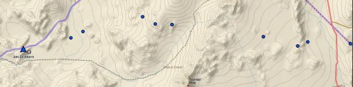
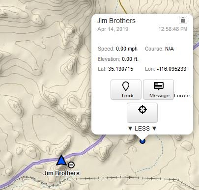
What are the blue dots along a trail and a big blue arrow with my name? it will not delete....
Educator I
12989
Here it is, looks like you can send a msg to me or something. They all have a delete but they never do. If you click on them you get the box in second attachment.
Jim
Educator I
12989