

Friends - I'm looking for info on the Allegheny-Shenandoah Overland Loop. Mainly trying to figure out if there is a set route and what trails are included, or it differs by adventurer. My understanding is that one route includes: George Washington National Forest, Flagpole Knob, Reddish Knob, Lake Moomaw, Monongahela National Forest, Canaan Loop, Dolly Sods, and Green Ridge State Forest. I can build my own route with onX through these areas, but wanted to first see if anyone knew if there was a set route for this loop. Also, if anyone has made this trip, I'd be very interested in anything we need to watch out for and any advice on the water crossings. This would be a fall run, so I've heard your more at risk of wet carpets in the spring than at other times of the year. Thanks for any advice that can be thrown my way! Cheers!
Allegheny-Shenandoah Overland Loop?
- Thread starter Roofus
- Start date

Enthusiast III
- 913
- First Name
- Anthony
- Last Name
- Trombley
- Member #
-
30229
Are you referencing the "Allegheny Discovery Route" found on the Overland Bound One app? I too am interested in doing that trail sometime, but I believe the app provides a .gpx file for you to use to navigate. If you do decide to run that route, I'd love to hear your review of it! I believe you can add a review of the trail on the app. The only review up right now it from the original trail creator in 2021.


Google gave me GaiaGPS - Allegheny and Shenandoah Overland Trail You can download the GPX from the Data tab on the menu.
Enthusiast III
I've made some of those water crossings, they're like big puddles that can be anywhere from 6" to maybe 30" deep and up to maybe 30' long, depending on time of year and of course rainfall. It's been really hot and dry so I doubt those will be much of an issue for you. Going up the Union Springs trail (to Flagpole knob) this weekend but not expecting much difficulty. The "trail system" is mostly fire roads, rocky and bouncey at times but not difficult in general. I'm pretty sure someone will read this and have other stuff to share
Enjoy the trip!!
Enjoy the trip!!
Thanks for the feedback everyone. I'm sorry for the slow response as I've just been swamped with work.
Krusty, Appreciate the feedback on the water crossings. I'm in a Bronco on 35's with 3" lift, so it sounds plenty manageable without worry about wet carpets.
Mr_Mnml_Engnr, I am not sure. I will have to look that up.
Kevin, yes I have that download from Gaia. I use onX Offroad and did the import. It seemed a bit off in places, so I went back through and basically recreated the route in onX by creating a new route that traced the loaded Gaia file. I'm only about 25% of the way back through the route tagging gas stations and camp sites from the Gaia map. And I'd like to add a few more tags of good lookouts/site seeing as I research. And I may have to adjust camping sites based on terrain. I tent camp so I can still take the roof off the Bronco, so rooftop tent sites won't work if the terrain is bad.
If I can get all of that done this month, then we are going to shoot for a late Oct or mid-Nov trip. I also need to get a sat communicator since there's no cell coverage in the south areas of the route as well as getting my air compressor installed (wiring is done, but need to install mount and compressor) before we made this trip. We will most likely have myself and a Prado making this trip. But based on "most" of the camping areas I've seen, I think we could do a 5 truck caravan pretty easily if not more. So I'd be open to meeting up with anyone who'd want to tag along.
I'll check in with more as soon as I'm able. Cheers!
Enthusiast III
<But based on "most" of the camping areas I've seen, I think we could do a 5 truck caravan pretty easily if not more.> Most of what I have seen can do 4 or 5 trucks as long as you're rooftop camping. There are some good sized sites but not huge. Good news is that many of them are very close together, a short stumble of less than a minute for most of them :)Thanks for the feedback everyone. I'm sorry for the slow response as I've just been swamped with work.
Krusty, Appreciate the feedback on the water crossings. I'm in a Bronco on 35's with 3" lift, so it sounds plenty manageable without worry about wet carpets.
Mr_Mnml_Engnr, I am not sure. I will have to look that up.
Kevin, yes I have that download from Gaia. I use onX Offroad and did the import. It seemed a bit off in places, so I went back through and basically recreated the route in onX by creating a new route that traced the loaded Gaia file. I'm only about 25% of the way back through the route tagging gas stations and camp sites from the Gaia map. And I'd like to add a few more tags of good lookouts/site seeing as I research. And I may have to adjust camping sites based on terrain. I tent camp so I can still take the roof off the Bronco, so rooftop tent sites won't work if the terrain is bad.
If I can get all of that done this month, then we are going to shoot for a late Oct or mid-Nov trip. I also need to get a sat communicator since there's no cell coverage in the south areas of the route as well as getting my air compressor installed (wiring is done, but need to install mount and compressor) before we made this trip. We will most likely have myself and a Prado making this trip. But based on "most" of the camping areas I've seen, I think we could do a 5 truck caravan pretty easily if not more. So I'd be open to meeting up with anyone who'd want to tag along.
I'll check in with more as soon as I'm able. Cheers!

Advocate I
How was Union Springs? I went in that way last Nov and there were a couple of ledges that had gotten dug/ rutted out that gave a bit of a pause with a stock suspension JKU. It wasn't that bad the previous times I traveled that route.I've made some of those water crossings, they're like big puddles that can be anywhere from 6" to maybe 30" deep and up to maybe 30' long, depending on time of year and of course rainfall. It's been really hot and dry so I doubt those will be much of an issue for you. Going up the Union Springs trail (to Flagpole knob) this weekend but not expecting much difficulty. The "trail system" is mostly fire roads, rocky and bouncey at times but not difficult in general. I'm pretty sure someone will read this and have other stuff to share
Enjoy the trip!!
Enthusiast III
Didn't make it up there between the rain a few days early and what was predicted on Saturday and a family thing that came up out of nowhere. So sadly I can't give a trail report, I'm trying to get myself together and take another run at it this weekend or next
Enthusiast III
- 913
- First Name
- Anthony
- Last Name
- Trombley
- Member #
-
30229
I’m planning to do a section of the trail end of this month with some local buddies. Will add a review of the trail and post it here when we do!
Enthusiast III
Let me know when? I might be able to tag along if there's room....29th is the only weekend I'm not available
CLARO86
Rank II

Enthusiast II
I am planning to do most of if not all of this route near the end of October with some friends. I'm still adding things to my plan, but cant wait to get out there for a week.

Off-Road Ranger I
We’ve done some sections. Some of the river crossings can be large but all have go around s.
That’s the route we have.
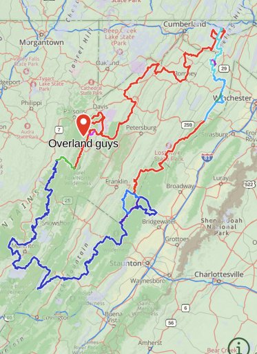
That’s the route we have.
Off-Road Ranger I
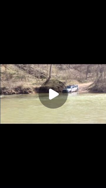
Sorry to share Instagram but it’s all I have of two crossings.

 www.instagram.com
 www.instagram.com
bear_den_overland on Instagram: "A redo with some changes crossing the Dry Fork. #overlandbound #outfitandexplore #toyotaoverland #overlandtoyotas #tacomaoverland #overlandtacoma #mountainstate #overland #overlanding #wanderlust #rooftop #rooftoptenting #rooftoptent #overlandfamily #overlandingfamily #familyoverlanding #familyoverland #tacomaworld #tacoma3g"
33 likes, 1 comments - bear_den_overlandJune 29, 2023 on : "A redo with some changes crossing the Dry Fork. #overlandbound #outfitandexplore #toyotaoverland #overlandtoyotas #tacomaoverland #over...".
www.instagram.com
bear_den_overland on Instagram: "Down and dirty on the Allegheny/Shenandoah Overland Route. Stock Height but slightly larger tires at that point. #tacomaoverland #toyotaoverland #overlandtoyotas #trdoffroad #tacomaworld #tacoma3g #familyoverlanding #familyoverland #overlandfamily #overland #overlanding #overlandbound #tacoma #taco"
21 likes, 1 comments - bear_den_overlandMay 16, 2023 on : "Down and dirty on the Allegheny/Shenandoah Overland Route. Stock Height but slightly larger tires at that point. #tacomaoverland #toyota...".
www.instagram.com
That doesn't look too bad. I've definitely got clearance for that assuming the water line hasn't risen. I'd imagine it would be lower in Oct/Nov than in May, no?Sorry to share Instagram but it’s all I have of two crossings.
bear_den_overland on Instagram: "A redo with some changes crossing the Dry Fork. #overlandbound #outfitandexplore #toyotaoverland #overlandtoyotas #tacomaoverland #overlandtacoma #mountainstate #overland #overlanding #wanderlust #rooftop #rooftoptenting #rooftoptent #overlandfamily #overlandingfamily #familyoverlanding #familyoverland #tacomaworld #tacoma3g"
33 likes, 1 comments - bear_den_overlandJune 29, 2023 on : "A redo with some changes crossing the Dry Fork. #overlandbound #outfitandexplore #toyotaoverland #overlandtoyotas #tacomaoverland #over...".
bear_den_overland on Instagram: "Down and dirty on the Allegheny/Shenandoah Overland Route. Stock Height but slightly larger tires at that point. #tacomaoverland #toyotaoverland #overlandtoyotas #trdoffroad #tacomaworld #tacoma3g #familyoverlanding #familyoverland #overlandfamily #overland #overlanding #overlandbound #tacoma #taco"
21 likes, 1 comments - bear_den_overlandMay 16, 2023 on : "Down and dirty on the Allegheny/Shenandoah Overland Route. Stock Height but slightly larger tires at that point. #tacomaoverland #toyota...".
Off-Road Ranger I
this is the link to the gauge. I think when we crossed it was about 2’8” at the gauge for reference.That doesn't look too bad. I've definitely got clearance for that assuming the water line hasn't risen. I'd imagine it would be lower in Oct/Nov than in May, no?
Dry Fork at Gladwin, WV
Monitoring location 03064800 is associated with a Stream in Tucker County, West Virginia. Current conditions of Gage height are available. Water data back to 2019 are available online.
Nice! Thank you! Yeah, 3'8" might be playing with fire. I'mma keep my eye on that.
Enthusiast III
Looks fun!!this is the link to the gauge. I think when we crossed it was about 2’8” at the gauge for reference.

Dry Fork at Gladwin, WV
Monitoring location 03064800 is associated with a Stream in Tucker County, West Virginia. Current conditions of Gage height are available. Water data back to 2019 are available online.waterdata.usgs.gov
Necro'ing this post. :)
We didn't end up getting to do the trip last year and went to Overland Expo instead. ha! But we were looking at the end of March as another possibility. I checked in on the water height today for the crossing and looks like it was at 8ft(!!) just a few days ago. The bottom of my door is 22" and my floor board is at 25". I'm assuming any higher than 2 feet and I'm dealing with wet carpets. Might avoid this obstacle.
We didn't end up getting to do the trip last year and went to Overland Expo instead. ha! But we were looking at the end of March as another possibility. I checked in on the water height today for the crossing and looks like it was at 8ft(!!) just a few days ago. The bottom of my door is 22" and my floor board is at 25". I'm assuming any higher than 2 feet and I'm dealing with wet carpets. Might avoid this obstacle.
Advocate I
Until later in summer, it’s probably going to be a crapshoot for water levels. I went though that area last year. I was by myself, so wasn’t going to risk a crossing. It’s not that much out of the way to bypass.Necro'ing this post. :)
We didn't end up getting to do the trip last year and went to Overland Expo instead. ha! But we were looking at the end of March as another possibility. I checked in on the water height today for the crossing and looks like it was at 8ft(!!) just a few days ago. The bottom of my door is 22" and my floor board is at 25". I'm assuming any higher than 2 feet and I'm dealing with wet carpets. Might avoid this obstacle.
Is the bypass pretty obvious to get back on the trail?Until later in summer, it’s probably going to be a crapshoot for water levels. I went though that area last year. I was by myself, so wasn’t going to risk a crossing. It’s not that much out of the way to bypass.
