Canaan Loop , WV

DirtyPawz

Rank IV

Enthusiast III

1,183
Nokesville, Prince William County, Virginia, United States
First Name
Brian
Last Name
Wing
Member #

31996

Service Branch
USCG
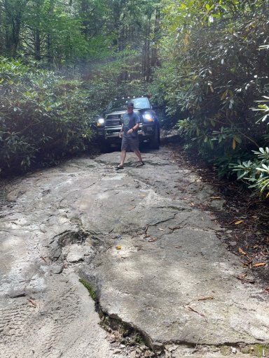
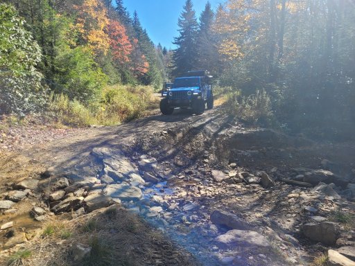
It was a little tight in some spots with all of the rhododendrons being overgrown and encroaching on the trail. It was definitely “soupy” with lots of mud puddles and some slick rocks.

Best thing I heard was “I’ve never seen a Cummins take on this part of the trail”.

And my wife who had never been off-road before had a crash course in guiding me over some big rocks.

Next time I’ll find a less right trail. But there were some pretty good dispersed campsites all along the trail.
 

Attachments

  • media.jpg
    media.jpg
    988.5 KB · Views: 27
  • media.jpg
    media.jpg
    522.9 KB · Views: 29
  • media.jpg
    media.jpg
    555.6 KB · Views: 29
  • media.jpg
    media.jpg
    616.2 KB · Views: 28
It’s also very popular. Camped there a few weeks ago. Arrived early on a Fri evening, found one of the last spots available. By early Sunday afternoon, 85% of the campsites were vacated.
Despite the popularity, one of our favorite places to go because of the beauty of the area.
 
I was closeby, trees are in peak leaf change which is nice. You might miss it in 2 weeks, have you been to Canaan before? The public half of the trail is a gravel road and very well maintained, nothing to worry about. Lots of campsites right off the road.
 
  • Like
Reactions: HaveeBear2
Just camped there last week, it was our first time in the area. We got there on a Monday and the place was pretty empty, i hear it fills up on the weekends. The upper half of the loop is unmaintained but nothing to difficult, was just pretty wet when we were there. I would also recommend the 4x4 trail that goes to Olson tower which is just above Davis as well.
 

Attachments

  • 20231023_134131 (1).jpg
    20231023_134131 (1).jpg
    1,005.5 KB · Views: 28
  • 20231023_142416.jpg
    20231023_142416.jpg
    1,021.9 KB · Views: 27
  • 20231023_143145.jpg
    20231023_143145.jpg
    657 KB · Views: 24
  • 20231024_103259.jpg
    20231024_103259.jpg
    886.6 KB · Views: 23
  • 20231024_103336.jpg
    20231024_103336.jpg
    1.1 MB · Views: 24
Just camped there last week, it was our first time in the area. We got there on a Monday and the place was pretty empty, i hear it fills up on the weekends. The upper half of the loop is unmaintained but nothing to difficult, was just pretty wet when we were there. I would also recommend the 4x4 trail that goes to Olson tower which is just above Davis as well.

Awesome! Thanks for the info. OnX is reporting the road to Olson tower is obstructed with a washout on canyon rim road. Is that still the case or is it repaired? Thanks again!
 
  • Like
Reactions: CLARO86
Awesome! Thanks for the info. OnX is reporting the road to Olson tower is obstructed with a washout on canyon rim road. Is that still the case or is it repaired? Thanks again!

I assume its referring to what is in that first picture I posted there, it is washed out but passable with most 4x4 rigs I would think. We had a wrangler and 2 gladiators get through just fine.
 
  • Like
Reactions: Ebrinker
Awesome! Thanks for the info. OnX is reporting the road to Olson tower is obstructed with a washout on canyon rim road. Is that still the case or is it repaired? Thanks again!

I assume its referring to what is in that first picture I posted there, it is washed out but passable with most 4x4 rigs I would think. We had a wrangler and 2 gladiators get through just fine.

Good deal, yeah I was wondering if that was the washout referenced! Thanks again!
 
  • Like
Reactions: CLARO86
Thinking about hitting up Canaan Loop in just under 2 weeks from now. Any recent trail reports? Looks like Davis might be getting some snow next week but still too early to tell.
I'm considering heading out that way on the 10th or 11th...maybe we'll run into each other
 
  • Like
Reactions: Ebrinker
Thinking about hitting up Canaan Loop in just under 2 weeks from now. Any recent trail reports? Looks like Davis might be getting some snow next week but still too early to tell.
I'm considering heading out that way on the 10th or 11th...maybe we'll run into each other

Good deal! Yeah we will be cruising around that Saturday is my guess.
 
Good deal! Yeah we will be cruising around that Saturday is my guess.
I'm new to that area, have any coordinates for a trail head or anything helpful like that? I'll be coming in from the south east (Staunton)

I haven’t been yet but here are the coordinates for the southern entrance to Canaan Loop Road that I found: 39.09793, -79.43076. The northern entrance is in Blackwater Falls State Park: 39.10645, -79.51399. Hope this helps!!
 
Just for the sake of covering all my bases I want to reiterate that the northern "unmaintained" half of Canaan Loop is private property. You'll want to contact Allegheny Wood Products for permission to enter.

Monongahela National Forest - Canaan Mountain Backcountry (usda.gov)

You'll see the USFS official route does not connect on their map.

image (27).jpg
 
Just for the sake of covering all my bases I want to reiterate that the northern "unmaintained" half of Canaan Loop is private property. You'll want to contact Allegheny Wood Products for permission to enter.

Monongahela National Forest - Canaan Mountain Backcountry (usda.gov)

You'll see the USFS official route does not connect on their map.

Whole-heartedly support double-checking for private ownership in places, however, I think you're mistaken here. Both GAIA and OnX show the route as a right-of-way through land owned by Scenic Vistas, LLC. Signs at either end indicate that high-clearance vehicles be used...that's it. The only questionable data I've ever seen on that route is it being listed as 2-way :laughing:. Someone's backing up a very long way through some very tight stuff if you come across oncoming traffic!

1698838757331.png
1698838862181.png
 
Whole-heartedly support double-checking for private ownership in places, however, I think you're mistaken here. Both GAIA and OnX show the route as a right-of-way through land owned by Scenic Vistas, LLC. Signs at either end indicate that high-clearance vehicles be used...that's it. The only questionable data I've ever seen on that route is it being listed as 2-way :laughing:. Someone's backing up a very long way through some very tight stuff if you come across oncoming traffic!

View attachment 268698
View attachment 268699

I try to be very good about double checking where I ride as well, having just gone through there, I was using GAIA and it appeared to be a through road as you show there. Also as you stated, there were absolutely no "no trespassing" or private property signs where the gravel turns to unmaintained.
 
  • Like
Reactions: Ebrinker and K9LTW
Whole-heartedly support double-checking for private ownership in places, however, I think you're mistaken here. Both GAIA and OnX show the route as a right-of-way through land owned by Scenic Vistas, LLC. Signs at either end indicate that high-clearance vehicles be used...that's it. The only questionable data I've ever seen on that route is it being listed as 2-way :laughing:. Someone's backing up a very long way through some very tight stuff if you come across oncoming traffic!

View attachment 268698
View attachment 268699


The US Forest Service link I provided earlier states that it's private property, not me. There very well may be a standing authorization and right of way in place, I just can't find it anywhere online. This area has been a legal battle for nearly 20 years and we need to follow the rules as USFS has laid out. The boundaries displayed on your map do support your comments though. I'm not trying to lean one way or the other I'm just trying to do this the right way.

I spoke with AWP this morning and I have a meeting with the AWP Land Manager first thing tomorrow morning. I'll post what I learn shortly after.

_______________________________________________________________________________________________________________________

Edit: I just spoke with the Cheat Ranger District Office, the USFS now owns the road. The land on either side of the road is still privately owned but we are authorized to use the road. No telling when they'll update their website and maps though.
 
Last edited:
The US Forest Service link I provided earlier states that it's private property, not me. There very well may be a standing authorization and right of way in place, I just can't find it anywhere online. This area has been a legal battle for nearly 20 years and we need to follow the rules as USFS has laid out. The boundaries displayed on your map do support your comments though. I'm not trying to lean one way or the other I'm just trying to do this the right way.

I spoke with AWP this morning and I have a meeting with the AWP Land Manager first thing tomorrow morning. I'll post what I learn shortly after.
Yeah...problem with MVUMs is they only reflect USFS infrastructure. It's pretty common to see a USFS route with no beginning nor end because the path to both lies outside of USFS-controlled land. They also, rarely, show rights-of-way. With that said, none of them are up-to-date either given the lack of resources they have. Heck...Virginia's hasn't been updated since 2015! We ran into myriad issues out west this summer where "roads" were actually private driveways. Good times.

Definitely interested to see what AWP says.

Just added a short edit to the end of my post, spoke with the Ranger Station down that way.

Not to derail this thread but yeah I despise the govt. website updating schedules haha. When I was in the Army we were required to only use forms from apd.mil, even if we knew the form had been updated we couldn't touch it until it was uploaded to the website.
 
  • Like
Reactions: K9LTW
Just added a short edit to the end of my post, spoke with the Ranger Station down that way.

Not to derail this thread but yeah I despise the govt. website updating schedules haha. When I was in the Army we were required to only use forms from apd.mil, even if we knew the form had been updated we couldn't touch it until it was uploaded to the website.
Thanks for the legwork on this! Good to have official word on it.

Having worked in the IC for over 20 years, and a short stint in the ARNG...don't get me started on the speed of gubment nor what we PAY for such "speed". :tearsofjoy:
 
  • Like
Reactions: Ethan N