SSOBMC (South Sound Overland Bound Meetup Club)

  • HTML tutorial

Would you like to host a future meetup?

  • Yes

    Votes: 1 50.0%
  • No Thanks

    Votes: 0 0.0%
  • Maybe later

    Votes: 1 50.0%

  • Total voters
    2
  • Poll closed .

a12houk

Rank VII

Off-Road Ranger I

5,701
Rochester, Washington, USA
First Name
Aaron
Last Name
Houk
Member #

41225

Ham/GMRS Callsign
GMRS: WRQJ715
Hey Everyone!

I wanted to create an ongoing forum thread to maintain the conversation since the conversation in the Rally Point will drop off after we've had the meetup.

I'm really looking forward to meeting people tomorrow! For those that can make it, see you there. For those that can't, I'm thinking about breakfast and a bonfire on April 23rd, location TBD. (Leaning toward Lonesome Lake above Greenwater)
 

A.Desert.Creature

Rank IV
Member

Member III

1,009
University Place, Washington, United States
First Name
Joshua
Last Name
Padgett
Member #

31160

Ham/GMRS Callsign
N7EEP
Hey Everyone!

I wanted to create an ongoing forum thread to maintain the conversation since the conversation in the Rally Point will drop off after we've had the meetup.

I'm really looking forward to meeting people tomorrow! For those that can make it, see you there. For those that can't, I'm thinking about breakfast and a bonfire on April 23rd, location TBD. (Leaning toward Lonesome Lake above Greenwater)
I appear to be free on that weekend April 22/23. Let's book it!
 
  • Like
Reactions: a12houk

a12houk

Rank VII

Off-Road Ranger I

5,701
Rochester, Washington, USA
First Name
Aaron
Last Name
Houk
Member #

41225

Ham/GMRS Callsign
GMRS: WRQJ715
Upcoming Meetup Dates
April 23 ~ Breakfast & Bonfire - Location TBD depending on snow melt near Greenwater
May 20-21 ~ ?? Basecamp + Trip Planning Seminar. Perhaps in the Whiskey Dick area near Vantage
June 10-11 ~ Possible WABDR-1
July 16 ~ This date could also be a trip launch. Perhaps the meetup is a farewell party?
 

MrWilsonWJ

Rank V
Launch Member

Member III

1,691
Kennewick, WA
First Name
Dustin
Last Name
Wilson
Member #

23384

If you're looking at the Whiskey Dick area I'm guessing you're familiar with the Washington State Green Dot Road system. If so another area to check out for your May trip is the Wenas Wildlife Area, I like it better than Whiskey Dick and the last two years it's been free of snow by early May. It has more trees around and access to more roads and trails. While at Whiskey Dick you can get some great views of the river and surrounding area, I think the views (on a clear day) area better in the Wenas area. Travel time from the west side would be pretty close to Whiskey Dick as you can enter the area from Section 2 of the WABDR it would just be more time on dirt to get to where the better camping is. If you're interested in this area let me know and I can send you some tracks, places of interest and possible camp locations.

Here's a couple pictures from the area.
5-15-10.jpg5-14-3.jpg5-14-1.jpg26_27_1.jpg
 

a12houk

Rank VII

Off-Road Ranger I

5,701
Rochester, Washington, USA
First Name
Aaron
Last Name
Houk
Member #

41225

Ham/GMRS Callsign
GMRS: WRQJ715
If you're looking at the Whiskey Dick area I'm guessing you're familiar with the Washington State Green Dot Road system. If so another area to check out for your May trip is the Wenas Wildlife Area, I like it better than Whiskey Dick and the last two years it's been free of snow by early May. It has more trees around and access to more roads and trails. While at Whiskey Dick you can get some great views of the river and surrounding area, I think the views (on a clear day) area better in the Wenas area. Travel time from the west side would be pretty close to Whiskey Dick as you can enter the area from Section 2 of the WABDR it would just be more time on dirt to get to where the better camping is. If you're interested in this area let me know and I can send you some tracks, places of interest and possible camp locations.

Here's a couple pictures from the area.
View attachment 252462View attachment 252463View attachment 252464View attachment 252465
Yes please!
I am aware of the green dot system, and I know they change which roads are open from time to time.

I’ve never been to the Wenas area. I would love some tips and tracks to check out!
 

MrWilsonWJ

Rank V
Launch Member

Member III

1,691
Kennewick, WA
First Name
Dustin
Last Name
Wilson
Member #

23384

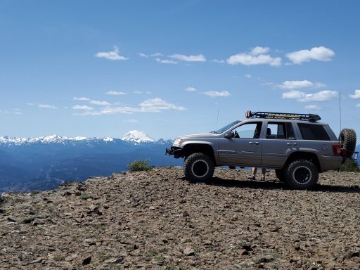
The green dot roads usually only close seasonally and from what I've seen that's just for winter animal habitat. Be careful if you are looking to go run some in the winter though because a lot of the ones open all year become groomed snowmobile trails. If you use Gaia they have a snowmobile trail map overlay that will show you which ones get groomed. They're a nice system of roads but I haven't been on any that are challenging or would consider a 4WD trail. I haven't tried it but I heard if you use their app that has the maps you can do tracking/mapping right on it. Below is a link for the maps for anyone that hasn't checked them out. Click the "Print your own map" link and it lists out all the areas.


There is a few different ways you can get to the Wenas area from I90 starting around Cle Elum but I think if you tried the western ones in May you would still run into snow. This first route linked below goes from Ellensburg to the Wenas area using Durr Rd. and includes about 20 miles from section 2 of the WABDR.

This one leaves Ellensburg in the same place but is more direct and made up of roads that can be traveled faster, both take you to the same place. It's nice to have options, fast way in Friday and long way out Sunday is what I like to do.

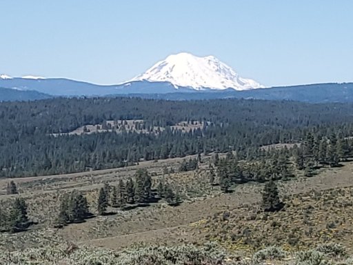
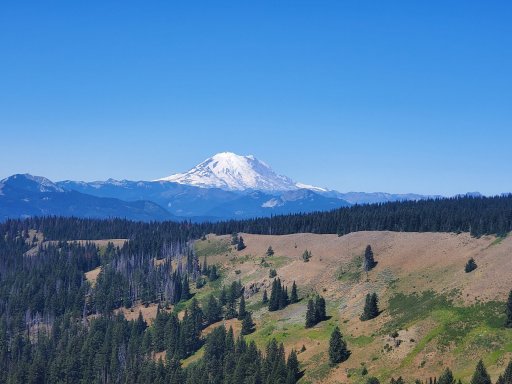
Below are two different tracks I recorded in the area, one is a loop around the NE portion of the area and the other is kind of SW with a little bit of overlap just because of where I was camping. The first track includes the same WABDR section as the route in from Ellensburg but also goes up on to the ridge past UW's (booo! Go Cougs!!) observatory. The second one goes up onto the southern ridge of the Wenas area and I would consider it more of a trail but still nothing difficult. In the second track you will see where I took Bald Mountain rd. down to highway 410 into Nile and back(needed fuel) that detour can be avoided by using forest road 1712. Also when going out (southeast-ish) Clemen MTN. ridge rd. you can go further out the ridge than I did and get a good view down into Naches.


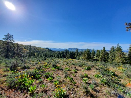
I had no real destination while out driving these so I was just cruising/wandering around, if you look it these tracks and the green dot maps together you'll see lots of other combinations to run these roads in loops. Once the rest of the snow melts you can access more of the trails and forest roads to the west from Hog Ranch Rd.
 

Altaholic

Rank II
Launch Member

Enthusiast I

404
Montesano, WA, USA
First Name
Dan
Last Name
Payton
Member #

20735

Service Branch
US Army
It's been a month since our meet-up for coffee and scheming grand plans. I haven't seen much traffic in a couple of weeks so I thought I'd reach out. Still thinking of a a breakfast and bon-fire next week?
 

A.Desert.Creature

Rank IV
Member

Member III

1,009
University Place, Washington, United States
First Name
Joshua
Last Name
Padgett
Member #

31160

Ham/GMRS Callsign
N7EEP
It's been a month since our meet-up for coffee and scheming grand plans. I haven't seen much traffic in a couple of weeks so I thought I'd reach out. Still thinking of a a breakfast and bon-fire next week?
My son and I are still down for something the weekend of April 23rd. Would love to get a light trail run in if there's enough interest.
 

a12houk

Rank VII

Off-Road Ranger I

5,701
Rochester, Washington, USA
First Name
Aaron
Last Name
Houk
Member #

41225

Ham/GMRS Callsign
GMRS: WRQJ715
I got up there a couple weeks ago and the snow level was really low.
I’ve been too busy to go scout anything.
I’m still down to have a bonfire, but I won’t have time to scout.

We could meet in Enumclaw at the Safeway and hope for the best.
 

Altaholic

Rank II
Launch Member

Enthusiast I

404
Montesano, WA, USA
First Name
Dan
Last Name
Payton
Member #

20735

Service Branch
US Army
We could just make the morning a scouting run. Maybe grab breakfast/lunch somewhere on the way out or in. Bag lunches for that matter. That way we spend a little more time wandering on the trails. Sunday would be the better day for me if options are there.
 

A.Desert.Creature

Rank IV
Member

Member III

1,009
University Place, Washington, United States
First Name
Joshua
Last Name
Padgett
Member #

31160

Ham/GMRS Callsign
N7EEP
We could just make the morning a scouting run. Maybe grab breakfast/lunch somewhere on the way out or in. Bag lunches for that matter. That way we spend a little more time wandering on the trails. Sunday would be the better day for me if options are there.
Sounds good. Either day works for me.
 

DintDobbs

Rank V

Advocate III

1,412
First Name
Daniel &
Last Name
the Vulture
@ThatRebelguy The first and best advice is to have an understanding of what kinds of terrain you're tackling and how to drive on them, the physics of your tire tread pattern, and whether/how much to air down.

Past that, always bring food and water, even if you're only planning to be out for a few hours. Stuck/breakdown conditions can leave you stranded all day or longer.

A shovel and first-aid kit, and a full-size, matching spare tire are common sense. Make sure you have a jack and tire iron to change your tire with. Utility knife and basic tool kit with sockets and an adjustable wrench are handy. Fire extinguisher, tow strap, and jumper cables can be helpful, hopefully you won't need them, but if you do, you'll wish you had 'em.