Chris,
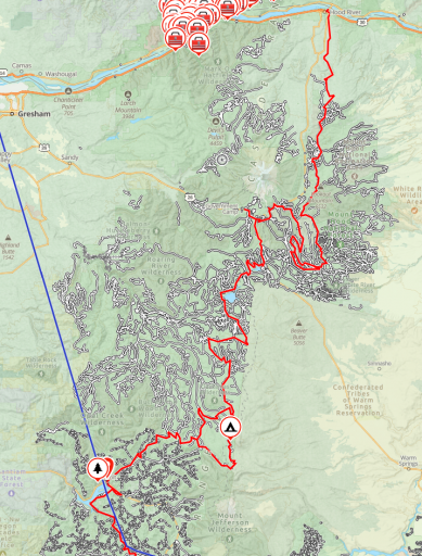
We do not get down to NW Oregon enough, but there is a good network of forest service roads on the west side of Mt Hood, FS Mainline road takes of North from Hwy 26 at the little town of Welches. you can follow that up onto Lolo Pass (Not to be confused with the Lolo Pass over in ID/MT. There are tons of spur roads all over up there. Its been a few years since we have been up there, and like many forest service areas a lot of the roads are getting gated due to dumping and people shooting up everything in site. I have attached a screen grab of the MVUM (Motor Vehicle Use Map) for your area and you can see tons of forest service roads along the cascades. The red line I have marked on there is the Oregon Backcountry Discovery Route. the Backcountry Discovery Routes are a series of point to point trails typically allowing one to travel across a state mostly on dirt. These have been put together by a group of adventure motorcycle riders and the overlanders have made use of them. They are essentially just a route someone chose through existing forest service roads linking together. Typically you won't find too much mud as they are gravel for the most part, but especially after the spring thaw there are areas that will provide more mud then your winch will be happy with:) Most of those routes take 5 or so days to travel at a leisurely pace and offer good dispersed camping and some awesome views of the state in the process. I have included GPX files for both WA and OR. the WA route takes of from Bridge of the GODS on the Columbia and heads north to Nighthawk at the Canadian border. The OR version heads south from Hood River. The GPX files can be loaded into the OB App or your favorite GPS software. MVUM maps are available from local Ranger Stations and online, Some of the GPS nav software include them also. Best way to know what roads are ok to travel on.
The John Day area farther east along the Columbia and heading down east of Bend has a ton of open BLM land to explore, can be pretty muddy in the rainy season and very slick. Advantage is a lot of it is accessible in winter months a it does not see a ton of snow but does get super cold.
Some lower level FS roads over on the coast (Tillamook area) Although that might just be an excuse to stop by the Tillamook factory and grab an ice cream cone.
If you are looking for really technical stuff search out ORV areas near you, there is the Rimrock area of Hwy 12 in Washington, they have some long trails big rocks and mud, however have not been out there in ages since I no longer have a rock bashing Jeep. Both of the ones we have now are set up for Overlanding, very capable, but just to heavy to do the King of the Hammers stuff.
Problem with the Western OR and WA is that almost all of our roads and trails go up and dead or go over a pass, so that limits winter travel due to snow. You can often only get up a few miles then blocked by snow drifts. Other issue each spring is blow downs. The first few people though in spring can expect to do a bunch of chainsaw work, and I recommend carrying one so you can get back out should a tree fall after you pass.
Overland Bound has been a bit slow up here for a while, not a lot of Rally Points posted for some reason. As Kent mentioned you can use the map on the app to message folks in an area around you. Sometimes a message alert will catch the attention of someone who has not been super active on the forums and they may respond. Once you have an area or trail picked out you can post a Rally Point event and it will notify local people that there is a trip. You never know how many folks will show up, might be a bunch and it might be just yourself, either way you still get to go out and have some off road therapy.
Hope you get out exploring soon so you can rub the shopping mall of your Taco.
Dave