• Guest, UPDATE We went through the site migration runbook and completed all steps. We will need to complete the migration next week, but will leave the forums up for the weekend. A few days after maintenance, a major upgrade revision to the forum site will occur.
  • HTML tutorial

Lets talk navigation

Baja-bro

Rank I
Launch Member

Traveler I

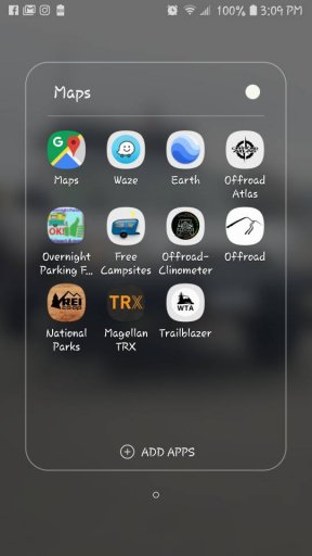
Currently i just use my cellphone with a number of map apps that i pre-download the areas im going.

I would like to run something a bit bigger, like an ipad mini or something alonge those lines. Would also like to be able to creat routes on my computer and pre load them as needed. Also want to track my route on scouting trips...

What is everyone running for this sort of overlanding stuff.. im open to ideas other then the Ipad as well. So lets see what y'all got..
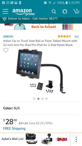
*PFA*FB_IMG_1534578291450.jpegScreenshot_20180819-150924_Samsung%20Experience%20Home.jpegScreenshot_20180819-151030_Amazon%20Shopping.jpeg
 

Enthusiast II

So far we just use a garmin 64st and paper maps. we can load routes and waypoints on the gps from our computer before we leave.
 

Steve

lost again...
Founder 500
Launch Member

Traveler III

What is everyone running for this sort of overlanding stuff.
Scroll down further in this forum for several discussions on recommended tablets, software etc. There's a lot of good advice here.
 

m_lars

Rank V
Launch Member

Off-Road Ranger I

I use a WiFi iPad with a Dual GPS receiver running the Gaia GPS app. It does everything you mentioned you’d like.
 

T-One

Rank V
Launch Member

Enthusiast III

My setup from a previous thread:

i run a Panasonic Toughbook CF-19 convertible with touch screen and a marine grade GPS chip for all things NAV in the car.
It's a ArchLinux based setup with marble Desktop for navigation, satellite images and OpenStreetMaps, it's a bit like Google Earth.

I prerender all the OSM data on my workstation and copy it to the toughbook so i have full offline maps.
Offline POI and address routing is handled by MoNav which integrates with marble completly.
For offline turn by turn navigation on roads i installed navit, but because i have a navigator with me all the time and she likes the sattelite map view within marble so much we don't use it often.
One of the killer features of this setup is the ability to fetch huge areas of satellite images and store them on an external HDD, with an OSM overlay merged into it it's like google earth/maps hybrid view but completely offline.

We are used to 3 renderings now and we prerender them for every area or country we go.
Thunderforests Mobile Atlas layout for high contrast street navigation.
Thunderforests Outdoor layout for all things away from streets.
And a hybrid rendering of satellite images with OSM Streets overlay.

It's also possible to add multiple online OSM providers in marble, free and commercial ones with all kind of different layouts and satellite image sources and just download a defined area for offline use within the application, but that's not a good approach if you have to handle huge areas for multiple week long trips.
 

DanW

Rank V
Launch Member

Member III

In addition to mobil apps, I run a Magellan TRX-7. The tablet itself is a somewhat slow Android, but I took it on a snowmobiling trip and mounted it to the handlebars. It performed VERY well, and had all of the trails in the Manistee, MI area, which really helped us. It had freezing rain and wet snow on it quite a bit, and it shrugged it off. I've got the trails we're doing in Moab saved on it, so it looks like it is good to go for our October trip out there. I'll use the Polaris app or something else as a back-up.
 
Top