

Hello everyone,
First of all I'll let you know I'm very excited to have joined this community. Thanks to all of you in advance for helping me with what I'm about to ask.
I'm planning a great road trip of the western United States. I'll be leaving early in June for about 20 days, traveling South from Calgary Alberta, Canada, through Yellowstone to Denver, then head West to LA, then North through Portland and back into Vancouver, Canada. Loosely laid plans...
I'm starting this thread as a kind of live & interactive travel planner, and I'm hoping for the community's input and expertise to avoid the unexpected. I'm comfortable with camping, but I'm not at all familiar with overlanding in the USA.
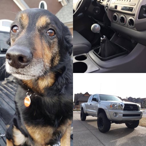
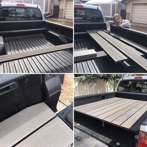
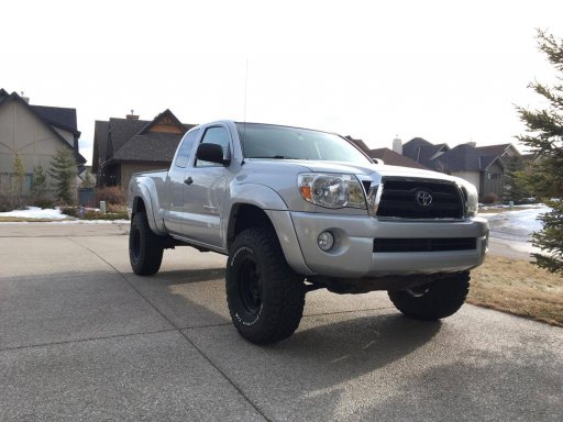
MY RIG (This is the foundation of my overland rig):
- 2008 Toyota Tacoma, TRD Off-Road (96,000km, 5MT, tip-top shape),
- Toytec Boss Suspension System,
- 285/75R16 BFG KO2s,
- composite sleeping platform,
- Softopper on the way
- Wilco Solo Hitchgate soon to be added with full sized spare
MY TRIP:
- Head South from Calgary toward Yellowstone, hopefully boondock on the North side of the park
- Spend a day ripping around Yellowstone and boondock on the South side of the park
- Head South to Denver to meet up with some homies
- From Denver we'll head West to LA, some stops along the way:
- The Alpine Loop Scenic Byway (?)
- Arches National Park
- Lake Powel
- The Grand Canyon
- Havasu Falls
- Mojave Road (?)
- Joshua Tree Nat. (Before or After LA depending on Mojave Road)
- From LA I'll head North, and from here I haven't made many plans... I'll drive as close to the coast as possible, probably stop at Sequoia, SanFran, and some other spots along the way (looking for recommendations at the moment, maybe the Rubicon?)
- I'll go through Portland, Seattle, and end up back in Vancouver Canada, before driving back to Calgary
MY QUESTIONS:
1) Where's Public Land in the US? Are BLM maps my best resouces? How about National Parks?
2) Do I need a fire permit for each National Park I camp in? How about on Public Lands?
3) How remote is the Alpine Loop Scenic Byway? Can I do it in a day? Do I need a SAT phone? Can I do it alone?
4) How challenging is the Mojave Road? Can I just do a short section of it? Do I need a SAT phone? Can I do it alone?
5) I'll have a full sized spare, but not a HiLift Jack (I don't have any trail armor) I'm just planning on using my emergency jack, and some blocks of wood... thoughts? I've never swapped a tire on a trail.
Thanks again everyone for reading and considering. Looking forward to what everyone has to say, and please make suggestions on where else I should go, so long as it's not too far of the planned route. Mostly I'm hoping for suggestions on easy overland trails that end in beautiful spots to spend the night.
Best regards,
Mike
P.S.
Rig photos:
First of all I'll let you know I'm very excited to have joined this community. Thanks to all of you in advance for helping me with what I'm about to ask.
I'm planning a great road trip of the western United States. I'll be leaving early in June for about 20 days, traveling South from Calgary Alberta, Canada, through Yellowstone to Denver, then head West to LA, then North through Portland and back into Vancouver, Canada. Loosely laid plans...
I'm starting this thread as a kind of live & interactive travel planner, and I'm hoping for the community's input and expertise to avoid the unexpected. I'm comfortable with camping, but I'm not at all familiar with overlanding in the USA.
MY RIG (This is the foundation of my overland rig):
- 2008 Toyota Tacoma, TRD Off-Road (96,000km, 5MT, tip-top shape),
- Toytec Boss Suspension System,
- 285/75R16 BFG KO2s,
- composite sleeping platform,
- Softopper on the way
- Wilco Solo Hitchgate soon to be added with full sized spare
MY TRIP:
- Head South from Calgary toward Yellowstone, hopefully boondock on the North side of the park
- Spend a day ripping around Yellowstone and boondock on the South side of the park
- Head South to Denver to meet up with some homies
- From Denver we'll head West to LA, some stops along the way:
- The Alpine Loop Scenic Byway (?)
- Arches National Park
- Lake Powel
- The Grand Canyon
- Havasu Falls
- Mojave Road (?)
- Joshua Tree Nat. (Before or After LA depending on Mojave Road)
- From LA I'll head North, and from here I haven't made many plans... I'll drive as close to the coast as possible, probably stop at Sequoia, SanFran, and some other spots along the way (looking for recommendations at the moment, maybe the Rubicon?)
- I'll go through Portland, Seattle, and end up back in Vancouver Canada, before driving back to Calgary
MY QUESTIONS:
1) Where's Public Land in the US? Are BLM maps my best resouces? How about National Parks?
2) Do I need a fire permit for each National Park I camp in? How about on Public Lands?
3) How remote is the Alpine Loop Scenic Byway? Can I do it in a day? Do I need a SAT phone? Can I do it alone?
4) How challenging is the Mojave Road? Can I just do a short section of it? Do I need a SAT phone? Can I do it alone?
5) I'll have a full sized spare, but not a HiLift Jack (I don't have any trail armor) I'm just planning on using my emergency jack, and some blocks of wood... thoughts? I've never swapped a tire on a trail.
Thanks again everyone for reading and considering. Looking forward to what everyone has to say, and please make suggestions on where else I should go, so long as it's not too far of the planned route. Mostly I'm hoping for suggestions on easy overland trails that end in beautiful spots to spend the night.
Best regards,
Mike
P.S.
Rig photos:
Attachments
-
 168.8 KB Views: 15


