
-
Forum Upgrades: Whats Going On? Video
-

Gaia/Garmin Overlander
- Thread starter DirtySox
- Start date


Member II
IMHO what is the point? Any of the 3rd party apps in the Overlander can be run on any smart device. If you like Garmin maps great. If not Gaia has plenty of other options equal to or greater than what Garmin offers. I have a Garmin InReach but never really use the maps from the Earthmate app I prefer what Gaia offers.
Last edited:

Enthusiast III
100% correct. Garmin is trying to exploit the overlanding community with a ridiculously expensive GPS. Gaia works great on a pad or phone of your choosing. I still have a GPS as a back up, actually one I didn’t mount on one of my bikes so it’s a motorcycle Garmin in my JeepIMHO what is the point? Any of the 3rd party apps in the Overlander can be run on any smart device. If you like Garmin maps great. If not Gaia has plenty of other options equal to or greater than what Garmin offers. I have a Garmin InReach but never really use the maps from the Earthmate app I prefer what Gaia offers.

Member III
I'm running both. I just got them and am still learning how to use them. When I can afford it, I tend to overdo things a bit. Especially when it comes to safety/recovery, so I'm also looking at it as having them back-up more than complement each other. So far, I'm finding the Overlander easier to use/understand how to use and finding more detailed maps in Gaia. We just did the Titus Canyon Trail in Death Valley. It's a well known, well traveled, 27 mile dirt road through some amazing terrain. It did not (or I couldn't get it to) show up on the Overlander. It did show up on GAIA. One thing I do like about the Overlander is that I can use the "street map" side for getting me to the trailhead & then the "offroad" side to follow the trail. I think this will be great for areas we aren't familiar with.
Last edited:
Enthusiast III
I'm running both. I just got them and am still learning how to use them. When I can afford it, I tend to overdo things a bit. Especially when it comes to safety/recovery, so I'm also looking at it as having them back-up more than complement each other. So far, I'm finding the Overlander easier to use/understand how to use and finding more detailed maps in Gaia. We just did the Titus Canyon Trail in Death Valley. It's a well known, well traveled, 27 mile dirt road through some amazing terrain. It did not (or I couldn't get it to) show up on the Overlander. It did show up on GAIA. One thing I do like about the Overlander is that I can use the "street map" side for getting me to the trailhead & then the "offroad" side to follow the trail. I think this will be great for areas we aren't familiar with.
Member II
Read this and save yourself $600That's good to know. I'll admit that I struggle with GAIA and hope that I can use the Garmin as my "safety net". Especially if I haven't downloaded any areas that I may wish to explore.

How to Download an Entire State Map with Gaia Topo - Gaia GPS
Learn how to download an entire state map with Gaia Topo so you're prepared for every backcountry adventure.
terryg
Rank V

Pathfinder III
I use the Gaia linked to the Apple Play on my Kenwood DDx9705S with 7" screen. I've used Gaia several times and love it. The down side, however, is you have to download the maps, which can be pretty unrealistic for a long distance OTR trip. You can use the Google (or Apple) Maps on your phone, which works great until you lose cell coverage, which has happened to me more than once - VERY frustrating.
So, I use the Gaia for my trail portion and my Garmin Nuvi to get me to the trailhead. I can see the advantage of the Overlander for both, but I don't think the Overlander has the map layer options that Gaia has. The Wild fire layer was indespensable as my wife and I toured Colorado this past summer.
So, I use the Gaia for my trail portion and my Garmin Nuvi to get me to the trailhead. I can see the advantage of the Overlander for both, but I don't think the Overlander has the map layer options that Gaia has. The Wild fire layer was indespensable as my wife and I toured Colorado this past summer.


Explorer I
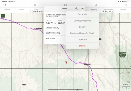
Create a route in Gaia and then tell it to download maps along the route. Simple and gives pretty good coverage on either side of your route. Make sure that all of the map layers that you want are currently active in Gaia or they will not be downloaded.The down side, however, is you have to download the maps, which can be pretty unrealistic for a long distance OTR trip.
Find your route and "click" on it to bring up description box
"Click" on the I / Info button on description box
"Click" on ellipsis (shown below)
"Click" on "Download Maps for Track" (shown below)
Easy peasy
ThundahBeagle
Rank V

Advocate I
I have a 10 year old Garmin GPS that I am using for road nav less and less as I've not been able to update it. I tend to use Google maps more now, so I got Gaia Free a few months ago. Great map detail ! I downloaded a few GPX files in the New England area and took a couple tours. Of course Gaia Free doesnt give you turn by turn, or keep the page focused on you (not that I figured out yet) so as i went along i would scroll the screen manually. Kind of a funny sight, but it worked for a while.
Do I have to play with it more, or is that a feature only found in the paid versions? I dont know yet, but I really like the map detail and the ease of loading in GPX files
Do I have to play with it more, or is that a feature only found in the paid versions? I dont know yet, but I really like the map detail and the ease of loading in GPX files
Explorer I
See above screenshot that I posted. Guide Me and Driving Directions are what you are looking for to guide you. Driving Directions takes you to Apple Maps (in my case) to provide turn by turn. I typically use this when I get into some town and I want to be shown the required turns to stay on route.
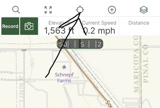
The red circle that almost looks like a reticle in the upper right corner is what you click to have Gaia plot your current location. Poke it several times to get different functionality (off, North up, Track up, etc). It will be a black circle/reticle until you poke at it to enable.
The red circle that almost looks like a reticle in the upper right corner is what you click to have Gaia plot your current location. Poke it several times to get different functionality (off, North up, Track up, etc). It will be a black circle/reticle until you poke at it to enable.
ThundahBeagle
Rank V
Advocate I
All in the free version? Wow, ok, thanks. I'll try it as soon as I have an opportunity
Explorer I
I believe so but have been paying for so long that I don't remember. Pretty sure what you get from paying is more/better maps and not additional app functionality.All in the free version? Wow, ok, thanks. I'll try it as soon as I have an opportunity
Let us know what you figure out!
Member II
I believe so but have been paying for so long that I don't remember. Pretty sure what you get from paying is more/better maps and not additional app functionality.
Let us know what you figure out!

Free versus Premium Membership
What's included in a Premium Membership to Gaia GPS? Unlock Gaia GPS's potential with a Gaia GPS Premium Membership. Learn about the added features and maps that come with a Premium Membership be...
 help.gaiagps.com
All the details are here.
ThundahBeagle
Rank V
Advocate I
Found it. Ok. When you tap on the map, on the route, the menu pops up and scroll to Guide Me. Takes you from wherever you are, to the route and then along it. Nice feature. I was getting tired of moving that map, but didnt want to try and feature hunt while I was out there.I believe so but have been paying for so long that I don't remember. Pretty sure what you get from paying is more/better maps and not additional app functionality.
Let us know what you figure out!
Thanks!
Member II
Tap this icon and it will center the map as well as change orientation of the map.Found it. Ok. When you tap on the map, on the route, the menu pops up and scroll to Guide Me. Takes you from wherever you are, to the route and then along it. Nice feature. I was getting tired of moving that map, but didnt want to try and feature hunt while I was out there.
Thanks!
ThundahBeagle
Rank V
Advocate I
Yep. I'd figured that and some other things out. Mainly the Guide Me feature was what I was looking for- something the ON road gps units do automatically. So it's a win!Tap this icon and it will center the map as well as change orientation of the map.
View attachment 180933
