
All Not Going
Vermilion Cliff Photography Trip May 12-14th, 2021
-
START DATE
09:00
09:00 AM Mountain Time (US & Canada)09:00 Hrs GMT -7:00 -
END DATE
Friday, May 14, 2021
09:00 AM Mountain Time (US & Canada)09:00 Hrs GMT -7:00
 RALLY POINT EVENT
 OVERLAND BOUND REGION
US Southwest
 EVENT TYPE
Trip
 DIFFICULTY
2 - EASY 2
Rally Point Event

Terrain Type
- Dirt Road
- Highway
- Sand

Recommended
- 4WD
- Off Road Tires

Channel
- HAM 146.460
Rally Point Details:
Disclaimer: We have not personally been to this location... yet. We have done extensive research and feel very confident in our planning.
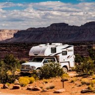
We intend to access Paria Plateau from US 89A via House Rock Rd. (improved dirt) to Pine Tree Rd. (dirt, varies). We'll head for White Pocket and find a good spot to set up camp. The final 5 - 8 miles are known to sometimes have deep sand with small stretches of rock. The BLM has posted the standard "4-wheel drive and high clearance vehicles only" signs, but we understand that most SUV with decent tires can make it without problems.
The second day we'll head out to explore the Paria Plateau. Since this is all National Monument (administered by the BLM), there is no off-road vehicular travel permitted. However, there are several unimproved dirt roads that look interesting. We'll be sure to make time to enjoy the opportunities for photos -- we're in no hurry. The loop we have planned for this day is about 40 miles but it could be more if we see interesting side trips. Again, some sand and minor rocky stretches anticipated, but nothing technical.
Since this will be a new moon period, the opportunities for night sky photography/time lapse photography (clouds permitting) should be spectacular. We plan on being up on at least one night to get time lapse of the Milky Way, which rises around 10:00 to 10:30 pm. It will be getting really high around 1:00 to 3:00 am. Saturn and Jupiter will also be putting in an appearance around 2:00 am. This is remote, so should qualify as a "dark sky" location.
We plan on driving out the morning of the 14th.
This is our first shot at organizing an OB Rally, so we're keeping it small.


 I
I
Pete P.
Member# 6184
- Start Point: Marble Canyon Airport, 540 US-89A, Marble Canyon, AZ 86036, USA GPS Coordinates: 36.81612, -111.64022 Notes: Meet at 9:00 am, departure at 9:30 am. Convenience store in Chevron Station for last minute supplies. Camping nearby at Lee\\\\\\\\\\\\\\\'s Ferry Campground, or the Badger Creek dispersed camping area.
- WayPoint 1: Unnamed Road, Marble Canyon, AZ 86036, USA GPS Coordinates: 36.77648, -111.65909 Notes: Badger Creek dispersed camping area.
- WayPoint 2: 1017 Pine Tree Rd, Marble Canyon, AZ 86036, USA GPS Coordinates: 36.862, -112.0627 Notes: Rock House Rd. & Pine Tree Rd. intersection
- End Point: Unnamed Road, Marble Canyon, AZ 86036, USA GPS Coordinates: 36.95507, -111.89301 Notes: We\\\\\\\\\\\\\\\'ll camp in this vicinity the night of 5/12 and 5/13. There are no facilities of any kind. You will need to be completely self-sufficient in terms of food, water, and toilet needs. Everyone is responsible for packing out all their own trash (leave no trace).
This Rally Point location and route can be downloaded if the buttons are active. The “Launch Google Earth" option will allow you to review the location in 3D. Please keep in mind, actual terrain may vary greatly. This should be used for reference only.
Save KML Save GPX PDF Launch in Google Map Launch in Google Earth
Comments