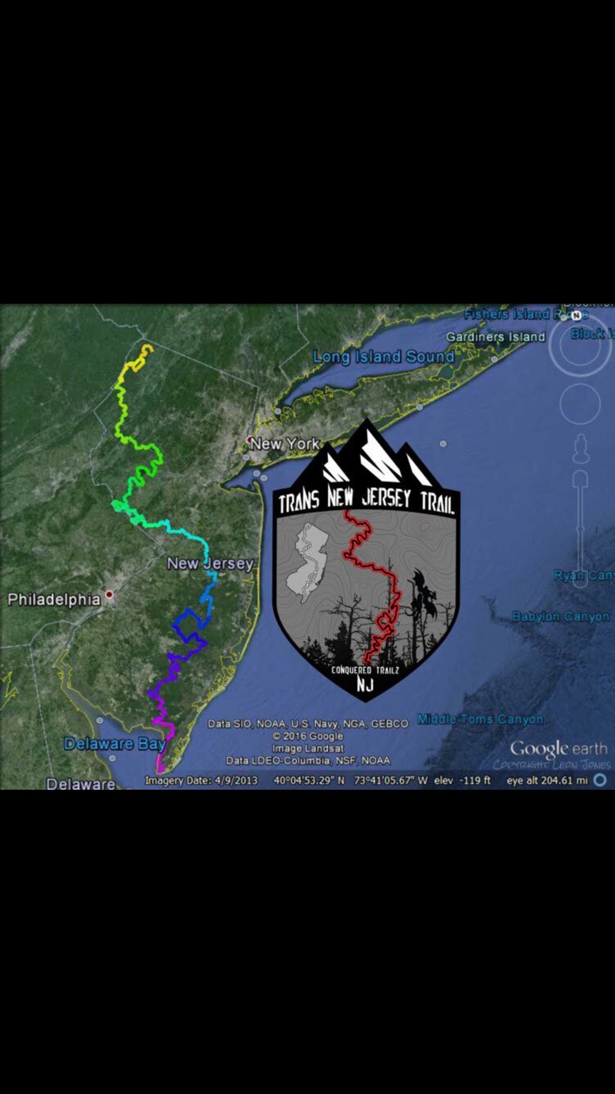
Trans-New Jersey Trail

  • HTML tutorial

Steve

lost again...
Founder 500
Launch Member

Traveler III

4,312
Lorain County, OH, USA
First Name
Steve
Last Name
None
Member #

202

Ah, another Mid-Atlantic Expeditions fan, huh? https://www.instagram.com/mid_atlantic_expeditions/

I've been on what looks to be the very northern section this last July, when we took our daughter to a summer camp north of Port Jervis. High Point State Park as a starting point, then down River Road (I recommend stopping at the Maple River Inn, right on the state line for lunch, as the food and hospitality was great!)
Then follow River Road down to Old Mine Road in Delaware Water Gap National Recreation Area, and through to Worthington State Forest. Some of it is narrow asphalt, and some gravel, with several side roads to the Delaware River.

That was our first road trip in the 4Runner, and the first time it was off pavement. The cover photo on our Facebook Page was taken on one of these side roads.

That section is only 46 miles, but with hiking in High Point State Park and meandering down the road, it took us all day. It is a beautiful area, as well as upriver from Matamoras.


NJ4runner

Rank III
Launch Member

Contributor II

528
Southern New Jersey, USA
Member #

3026

Ah, another Mid-Atlantic Expeditions fan, huh? https://www.instagram.com/mid_atlantic_expeditions/

I've been on what looks to be the very northern section this last July, when we took our daughter to a summer camp north of Port Jervis. High Point State Park as a starting point, then down River Road (I recommend stopping at the Maple River Inn, right on the state line for lunch, as the food and hospitality was great!)
Then follow River Road down to Old Mine Road in Delaware Water Gap National Recreation Area, and through to Worthington State Forest. Some of it is narrow asphalt, and some gravel, with several side roads to the Delaware River.

That was our first road trip in the 4Runner, and the first time it was off pavement. The cover photo on our Facebook Page was taken on one of these side roads.

That section is only 46 miles, but with hiking in High Point State Park and meandering down the road, it took us all day. It is a beautiful area, as well as upriver from Matamoras.

I did see this via Mid-Atlantic Expeditions! I'm considering doing it


Sent from my iPhone using OB Talk
 

Ironhide Fx4

Rank IV
Launch Member

Advocate II

1,080
VT
Member #

3576

I definitely want to give this a shot. I met with Leon of mid Atlantic a little while back, great dude. I look forward to him releasing the map files.
 
  • Like
Reactions: NJ4runner

Philbobagginz

Rank V
Founder 500
Launch Member

Influencer II

2,296
Brick, NJ
Member #

0371

Hey guys! Thanks for showing interest in the TNJT. Check out our instagram(link in my sig) and follow along as we prepare for our trip!
 
  • Like
Reactions: Steve

Xplorr313

Rank V
Founder 500
Launch Member

Enthusiast III

2,421
Burlington, NJ
First Name
Leon
Last Name
Jones
Member #

0313

Ham/GMRS Callsign
WQYY816
Hey guys, glad to see some interest in the TNJT on here. If anyone has any questions or want to know any info about the TNJT, feel free to ask me if I don't cover all of your questions here in this post. I'm the guy who took the ADVRider .gpx files and completely redid them to accommodate four wheeled vehicles, excluding ATVs and UTVs.

The ADVRider version of the TNJT had a many spots where the trail had you going down some really tight single track, around locked gates, trespassing on private property, riding on closed roads/trails within certain state forest, and there were a bunch of unneeded "loops" along their routes. These "loops" are considered as "hero" sections. Usually the "hero" sections are really technical sections; technical to enduros and adventure bikes.

Due to the laws that the New Jersey Park System and Department of Environmental Protection have set, freeroam/wilderness camping is prohibited. All camping must be done within state parks, private campgrounds, or on private property. Camping for the TNJT can be reserved through the www.reserveamerica.com website. As I had recently found out, all state owned campsites are required to be reserved for a minimum of two nights. The only exclusion to this is by reserving a much more expensive group campsite. Group sites require a minimum of at least seven people to camp and you CAN NOT park near the site. There are usually designated parking lots for the group sites.

The two night reservation on camping is a huge bummer but I was told, by NJSP personnel that you can reserve two nights at one park and overlap those stays in the other parks along the TNJT. What I mean by overlapping is that if you were to make this trip a four night / three day trip, you will need to reserve two nights at the first park, reserve two nights at the second park, reserve two nights at the third park, and reserve two nights at the last campsite. This equals in four wasted nights, which is not cheap at all considering for in state residence's cost are $20 a night before reservation cost ($9) and taxes. I was also informed that you can book the two nights for all parks you plan to overnight in and then a few weeks before your stay, you can cancel the second night and receive a refund for that one night that you won't use. I do not know how true this is, but we will find out shortly when Phil and I do our expedition of the trail.

For anyone who does not know what the Trans New Jersey Trail is; the trail is a 450+ mile trail that consist of asphalt, gravel, dirt, and sandy roads. The trail starts in the High Point State Park at the High Point Monument. The trail heads south from there, taking backroads all the way to Cape May, NJ. The trail ends at the Cape May Lighthouse in Cape May, NJ. Along the trail, you will encounter everything that New Jersey has to offer either it be scenic views, historical places, active farms, and beautiful beaches. A lot of the POIs along my version of the trail are places that I have found while out exploring NJ, places that are worth the visit if you have the time.

Having spent a ton of time, effort, and money to make this trail possible; the .gpx files, patches, decals and other items will be available for purchase/donation after Phil and I complete our trip. We have planned to do the three, maybe four, day trip this coming Easter weekend; April 13th-16th (maybe the 17th).

You're probably wondering what to expect when you take this trip. As for terrain, anyone with a awd/4wd vehicle should be able to complete the trail without any issues. There are water crossings, not of the creek or river kind but of the mud hole kind, that can easily hydrolock a motor if you are not prepared or you decide to choose the wrong line through the hole or around the hole. There are NO rocks to "crawl" on this trail. There are a couple hill climbs along the trail but they are NOT required to be traversed to complete the trail. Most of all the "offroad" sections are either legal gravel roads, legal dirt roads, or legal soft sand roads. I highly recommend recovery boards for the sand if you do not have a winch or you are in a awd vehicle like a Subaru. These soft sand roads should not be an issue for a true 4wd vehicle if you know how to drive your vehicle through those kinds of conditions.

Gas stations are few and far between one another. I highly recommend having a vehicle that can easily get a 200+ mile range on a full tank of fuel, or I highly recommend carrying fuel with you. Gas stations are not listed as POIs. You will need to search for those yourself since everyone's fueling needs are different.

Food, either it be grocery stores or restaurants, is easily accessible along the trail, but I highly recommend to pack food and water for you and your occupants. I mean you'd do this anyways for any camping trip right?

There are no hard copies, paper copies, of the TNJT. I was trying to work with the guys at Purple Lizard Maps to come up with a three part map for the trail, but they did not seem interested in this. If you need a hard copy of the trail, I would recommend picking up a New Jersey Delorme map book from Amazon or Barnes and Noble and actually go through the book highlighting the routes and make a list of each page of the book that you will need to look at if you're following the trail per the Delorme map book.

Again, all parts of the trail are legal roads/trails that you should not have any issues traversing down as long as you treadlightly. Please do not venture off of the dirt/gravel/sandy roads at any point of the trail. No matter how inviting some sections off of the trail look, these locations are considered "offroading" and "offroading" IS ILLEGAL in all of the New Jersey State Parks. If you are wanting the .gpx files of the TNJT for finding "offroading" or "wheeling" spots, I HIGHLY URGE YOU TO LOOK ELSE WHERE. Go to Rausch Creek Offroad Park if you want to "offroad" or "wheel".

If you have any questions or want anymore info, again, please feel free to ask. I hope this answers alot of your questions. Be sure to follow us on Instagram, Facebook, and YouTube as we prepare ourselves for this epic journey of what will be our first overland adventure as Mid-Atlantic Expeditions.
 

Glenn

Rank VI
Launch Member

Advocate I

3,384
New Tazewell, Tennessee, USA
First Name
Glenn
Last Name
Cote
Member #

3112

We are very interested in doing this. The camping scene is kind of a bummer , but not a deal breaker by any means. If the camps are nice we would just do the 2 nights in each camp. I hate feeling rushed and love new places to explore ... :smile:
One thing that struck me as kinda funny was the fuel vs food planning. Ive learned through the years that if there are restaurants and groceries , then by god you will find fuel...lol :smile:

What are the camp names you need to reserve in?
 
  • Like
Reactions: TheDistanceBetween

Ironhide Fx4

Rank IV
Launch Member

Advocate II

1,080
VT
Member #

3576

I also like to take it a little more leisurely. I would probably break the trek up to a couple weekends. Do a bit then spend 2 nights in camp relaxing.
 

Glenn

Rank VI
Launch Member

Advocate I

3,384
New Tazewell, Tennessee, USA
First Name
Glenn
Last Name
Cote
Member #

3112

I also like to take it a little more leisurely. I would probably break the trek up to a couple weekends. Do a bit then spend 2 nights in camp relaxing.
For us being in CT, this would be about a 5 hr drive just to start at the North end it so this would make a great week vacation for us, probably camping in 3 places just for fun. I have to learn more about this trip for sure.
 

Ironhide Fx4

Rank IV
Launch Member

Advocate II

1,080
VT
Member #

3576

For us being in CT, this would be about a 5 hr drive just to start at the North end it so this would make a great week vacation for us, probably camping in 3 places just for fun. I have to learn more about this trip for sure.
Yeah, that would work perfectly if you could make it a week vacation. Not a bad idea at all.
 

Xplorr313

Rank V
Founder 500
Launch Member

Enthusiast III

2,421
Burlington, NJ
First Name
Leon
Last Name
Jones
Member #

0313

Ham/GMRS Callsign
WQYY816
We are very interested in doing this. The camping scene is kind of a bummer , but not a deal breaker by any means. If the camps are nice we would just do the 2 nights in each camp. I hate feeling rushed and love new places to explore ... :smile:
One thing that struck me as kinda funny was the fuel vs food planning. Ive learned through the years that if there are restaurants and groceries , then by god you will find fuel...lol :smile:

What are the camp names you need to reserve in?
2 nights in each camp would be ideal, but for our trip it's impossible due to time restraints.

As for the food and fuel, there are some fuel spots along the way and yes where there is food there usually is fuel. When I say that a lot of this trail is strictly backroads, it really is and you will have to venture off of the trail to find food or fuel. Even though NJ is as populated as it is, there are still a lot of country side and wilderness left in NJ.

On one of the prerun trips of the northern section, one of the guys that was with us needed fuel and we ended up having to get off the trail and drive about 5-10 miles to the closest gas station. Before I make the route available, I'll be sure to go through it and try to add some more POIs for gas stations that are right along the route.

I do have 2 very important fuel stops listed already. One of those stops is about a 1/4 of the way into the central section. This fuel location is highly recommended since you will spend a few hours, 2-3hrs in wooded wilderness. Once you pop out on Route 70, you will have a chance to stop one last time for fuel before continuing all the way to Batsto via 90% dirt roads in the wooded wilderness that makes up multiple state parks. I'll post a screen shot of what I'm talking about soon.

These are the parks that I recommend camping in:

High Point State Park

Spruce Run State Park

Brendan T Byrne State Forest

Wharton State Forest (not necessary if you camp in Brendan T Byrne, but it would be a good spot if you skip Brendan T Byrne)

Belleplain State Forest (Park) (this stop is not necessary if you stayed at one of the many sites in Wharton State Forest. It all depends on where you decide to stop and call it a day at.)


When Phil and I do our trip, we have it planned to drive up to High Point after work and camp there on Thursday the 13th, wake up early on Friday the 14th and drive south to Spruce Run (about 100-140 miles south of the starting point. Stopping here depends on if Phil has a 3 day weekend or a 4 day weekend). If we skip Spruce Run, we will only have 2 other choices..1 stay in a friends front yard..2 drive 10+ hours, 245+ miles, in one day and make it to Brendan T. Byrne for camping that Friday night. Wake up kinda early in the day Saturday the 15th and drive until we reach Belleplain State Forest. Camp there and then Sunday we would drive the remaining 30-50 miles to the finish. This way our Sunday can be spent relaxing, celebrating our journey, and giving us enough time to make it back home at a decent time.

If Phil is able to get the 4 day weekend, our trip will go like this:

High Point on 13th

Spruce Run on 14th

Brendan T Byrne on 15th

Belleplain on 16th

Cape May (finish) on the 17th.
 

NJ4runner

Rank III
Launch Member

Contributor II

528
Southern New Jersey, USA
Member #

3026

For us being in CT, this would be about a 5 hr drive just to start at the North end it so this would make a great week vacation for us, probably camping in 3 places just for fun. I have to learn more about this trip for sure.
Make sure to follow Mid-Atlantic Expeditions on Instagram and Facebook. Should be awesome to follow their journey!


Sent from my iPhone using OB Talk