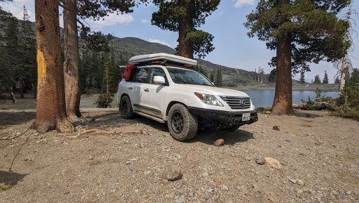
Traveler III
About 1.5 weeks, I had invited a group of friends out to the Downieville / Lakes Basin Area to hopefully take on the Lost Sierra Trail and capture some video along the way. Well, the Dixie fire wasn't having any of that as her smoke continued to bellow into the atmosphere and creep southward filling the mountains and valleys. We came up with a number of contingency plans for this very situation, and after a lot of back and forth we decided to head southward to El Dorado National Forest.
If videos are most your style, you can check out the nice little route guide we created HERE.
Day 1: Blue Lakes and Mud Lake
I'd put together what appears to be a promising route, especially looking at satellite images and the surrounding topography of our route. If you're familiar with our routes, you know they consist of primarily forest service roads of dirt and gravel, but I knew this track also had some jeep tracks along the way including out to Blue Lakes and Pardoe's Jeep Trail. Pardoes had been closed for a number of years and only re-opened within the last few years, so I couldn't find a ton of info on the trail (more on this in a little bit). The plan was to meet at Burnside Road and head up Hawkins Peak. I knew this was right on the edge of the fire closure for the Tamarack Fire, but the latest map put out by Humboldt-Toiyabe NF showed the road and surrounding area was out of the closure. I was the first to arrive at Burnside Road and quickly discovered the road was temporarily closed due to the fire. I decided I'd take Shasta (our 1.5yo husky/shepard mix) for a walk to kill sometime, and help her burn off some energy after being in the car for the last 3.5 hours. We encountered a truckload of hotshots leaving the area, and they even informed me we could drive out to Burnside Lake as long as we didn't explore any of the side roads. 40 min later I returned to the car to discover Ed and Dean talking to another couple. Ed and his brother Dan arrived in Ed's Jeep Rubicon about 10 minutes later. We discussed the situation, and ultimately decided to skip visiting Burnside Lake and we'd move on to the next portion of the route, which was a nice little loop through Hope Valley and Blue Lakes.
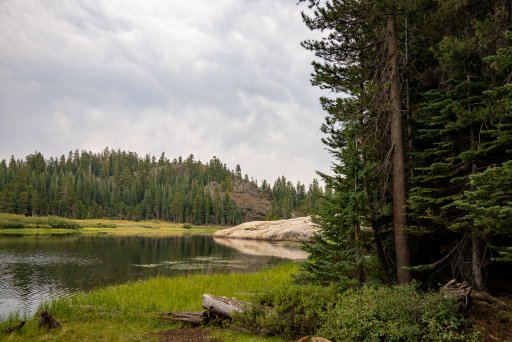
The road through Hope Valley is paved but absolutely gorgeous. Soon the road turned to gravel as we made our way through the the Blue Lakes area. As we gained elevation the road quickly grew more rugged, and we opted for a quick lunch break at Lost Lake. A solitaire female sans bathing suit was enjoying her very own private resort until we arrived, at which point she quickly covered herself up. The jeep trails around Lost Lake looked rather promising, and perhaps we'll explore them next time we're out. After lunch we continued on our way climbing over 8,000'. The trail and surrounding mountains were absolutely spectacular. The only downer was the haze that was turning craggy peaks into brown silhouettes. We trudged on with a short stint down highway 88 before heading over towards Pardoes Trail. We opted to check out Mud Lake, which was a blessing in disguise as it turned out to be a real gem and we decided it would be our camp for the night. The hundred or so cows weren't too pleased with our arrived, but the chorus of cow bells was bizarre and soothing at the same time.
The skies had grown ever more ominous on our way to mud lake, and finally the thunder gave way to a burst of rain and wind that lasted about 45 minutes. The thunderstorm blew out much of the smoke, and we'd hoped the crisp air conditions would hold for the rest of our trip. Our friends Kiley and Renee had planned to meet us at camp, and arrived around 10:15 pm with some help from communicating via Garmin InReaches. We'd turned in early that night, so no one had even heard them arrive.
Lost Lakes
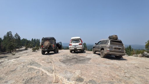
Forestdale Divide
More Forestdale Divide
Mud Lake
Day 2: Pardoe's Trail aka 12 miles over 5 hours
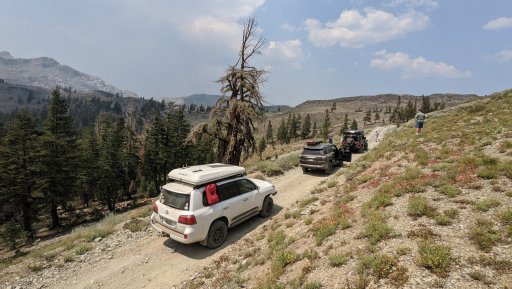
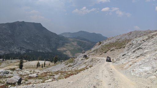
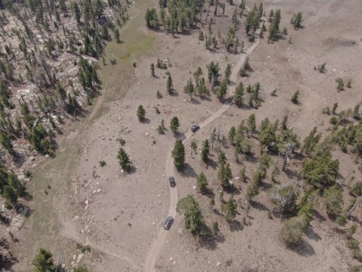
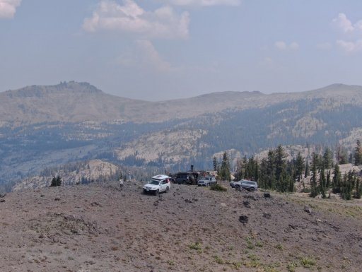
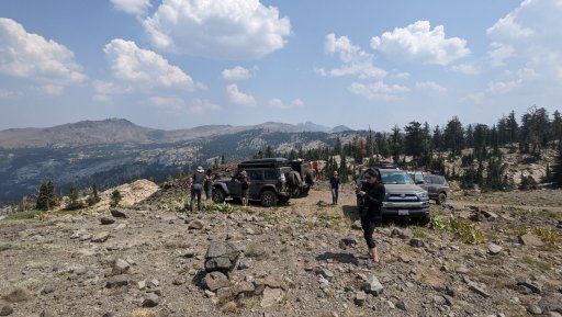
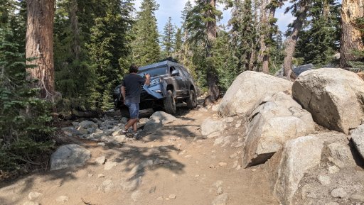
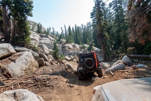
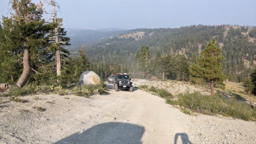
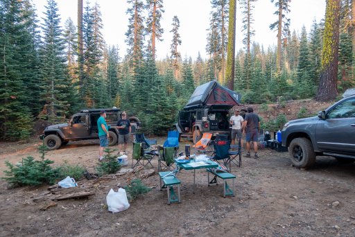
The next morning we discussed plans, and I set some expectations around Pardoes Trail. I told the group it was a jeep trail of unknown technical difficulty as I had difficulty tracking down reliable information about the trail online. From Mud Lake we climbed back up the ridge and once at Pardoes we worked our ways north to a spectacular viewpoint sitting at about 9,000'. We opted for a snack/photo break and I decided I needed to launch the drone to capture some photos and videos. The group was riding a natural high thanks to the geological wonders of mother earth. That'd soon come to an end as we entered Pardoes Trail. Pardoes is a tight jeep trail suited to short wheelbase SUVs like 4Runners and Jeep Wranglers. You'd better have a lift and sliders too! My LX570 was really pushing the limit in terms of size and what could make it through the trail. Don't even think of trying Pardoes if you're in a full size truck or a mid size truck with a longer wheelbase! Pardoes started out as a mildly technical yet tight track-- lots of snaking through trees and some occasional rocks. It wasn't so bad, expcept it kept going mile after mile, and then the granite boulder fields arrived and really slowed down the group. We were jumping out and spotting vehicles every 100 yards or so, and our already sloth-like pace slowed to a crawl. The group was growing stressed from exhaustion, as we hadn't planned for the trail to be an all day affair. Our buddy Todd's jeep sits on 35s with extra clearance, he made much of the obstacles look like a cakewalk. But for a typical overlanding rig with a 2-3" lift and sliders and 33" tires, the trail was a bit of a slog especially since we hadn't come mentally prepared to spend 5-6 hours on the trail. The one saving grace were the views-- absolutely spectacular! And things finally did calm down a bit, and we were able to take in the alpine vistas, distant peaks, and rather unique rock outcroppings. We had an opportunity to check out Upper Pardoes Campsite, but we ended up driving past it down towards Bear River Reservoir. This was probably a mistake, because upon looking at the satellite images upon pulling back into OTG HQ, the site looks rather promising. Instead, we ended up on a dead end spur road at Hams Spring. It wasn't all that bad as we were surrounded by 150' tall Noble Fir. The group was tired, but excited to recount the many trials of the day. Luckily the group didn't experience any sort of mechanical issues, and our buddy Ger sustained some very minor damage to his rear bumper/side panel.
Hungalelti Ridge (formerly known as Squaw Ridge)
Hungalelti Ridge
Hungalelti Ridge
Pardoe's Trail
Pardoe's Trail
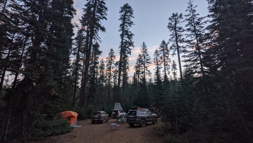
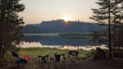
Camp
Day 3: Destination Water
The first couple of days we'd spent all of our time between 7000-9000 feet. Day 3 we'd be snaking our way through lower elevation trails ranging from 5500 -7000 feet. The trails were definitely tamer than Pardoes as no spotting was required, but we did hit some rocky tracks above Bear River Reservoir and some other trails scattered about-- trails best suited to a stock 4x4, but I supposed an AWD vehicle with an aftermarket lift would work just fine as well (but you'd get beat to $h** in something like a stock Subaru). Most of our mileage was spent in the forest, with occasional views of the surrounding ridges and peaks, but nothing like Blue Lakes or Pardoes. One of the highlights of this leg of the trip was Alder Ridge Lookout, and nice granite playground not far from Capps Crossing, and swimming in the American River. Alder Ridge Lookout consists of a 100' + tall tower secured by 4 cables and wooden steps. I'm not sure how much longer those wooden steps will hold, so best go before the forest service shuts the place down. We'd passed a number of great campsites along water, but the water levels were so low that it wasn't worth it. Instead we checked out a couple of campgrounds and we were lucky enough to score a site at China Flat, right on the American River-- score! We spent the rest of the evening relaxing int he river, enjoying beers, and Its-Its thanks to Kiley and Renee!
Granite Slabs Playground
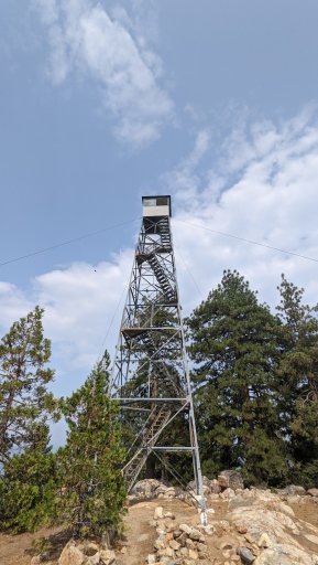
Alder Ridge Lookout
If videos are most your style, you can check out the nice little route guide we created HERE.
Day 1: Blue Lakes and Mud Lake
I'd put together what appears to be a promising route, especially looking at satellite images and the surrounding topography of our route. If you're familiar with our routes, you know they consist of primarily forest service roads of dirt and gravel, but I knew this track also had some jeep tracks along the way including out to Blue Lakes and Pardoe's Jeep Trail. Pardoes had been closed for a number of years and only re-opened within the last few years, so I couldn't find a ton of info on the trail (more on this in a little bit). The plan was to meet at Burnside Road and head up Hawkins Peak. I knew this was right on the edge of the fire closure for the Tamarack Fire, but the latest map put out by Humboldt-Toiyabe NF showed the road and surrounding area was out of the closure. I was the first to arrive at Burnside Road and quickly discovered the road was temporarily closed due to the fire. I decided I'd take Shasta (our 1.5yo husky/shepard mix) for a walk to kill sometime, and help her burn off some energy after being in the car for the last 3.5 hours. We encountered a truckload of hotshots leaving the area, and they even informed me we could drive out to Burnside Lake as long as we didn't explore any of the side roads. 40 min later I returned to the car to discover Ed and Dean talking to another couple. Ed and his brother Dan arrived in Ed's Jeep Rubicon about 10 minutes later. We discussed the situation, and ultimately decided to skip visiting Burnside Lake and we'd move on to the next portion of the route, which was a nice little loop through Hope Valley and Blue Lakes.
The road through Hope Valley is paved but absolutely gorgeous. Soon the road turned to gravel as we made our way through the the Blue Lakes area. As we gained elevation the road quickly grew more rugged, and we opted for a quick lunch break at Lost Lake. A solitaire female sans bathing suit was enjoying her very own private resort until we arrived, at which point she quickly covered herself up. The jeep trails around Lost Lake looked rather promising, and perhaps we'll explore them next time we're out. After lunch we continued on our way climbing over 8,000'. The trail and surrounding mountains were absolutely spectacular. The only downer was the haze that was turning craggy peaks into brown silhouettes. We trudged on with a short stint down highway 88 before heading over towards Pardoes Trail. We opted to check out Mud Lake, which was a blessing in disguise as it turned out to be a real gem and we decided it would be our camp for the night. The hundred or so cows weren't too pleased with our arrived, but the chorus of cow bells was bizarre and soothing at the same time.
The skies had grown ever more ominous on our way to mud lake, and finally the thunder gave way to a burst of rain and wind that lasted about 45 minutes. The thunderstorm blew out much of the smoke, and we'd hoped the crisp air conditions would hold for the rest of our trip. Our friends Kiley and Renee had planned to meet us at camp, and arrived around 10:15 pm with some help from communicating via Garmin InReaches. We'd turned in early that night, so no one had even heard them arrive.
Lost Lakes
Forestdale Divide
More Forestdale Divide
Mud Lake
Day 2: Pardoe's Trail aka 12 miles over 5 hours
The next morning we discussed plans, and I set some expectations around Pardoes Trail. I told the group it was a jeep trail of unknown technical difficulty as I had difficulty tracking down reliable information about the trail online. From Mud Lake we climbed back up the ridge and once at Pardoes we worked our ways north to a spectacular viewpoint sitting at about 9,000'. We opted for a snack/photo break and I decided I needed to launch the drone to capture some photos and videos. The group was riding a natural high thanks to the geological wonders of mother earth. That'd soon come to an end as we entered Pardoes Trail. Pardoes is a tight jeep trail suited to short wheelbase SUVs like 4Runners and Jeep Wranglers. You'd better have a lift and sliders too! My LX570 was really pushing the limit in terms of size and what could make it through the trail. Don't even think of trying Pardoes if you're in a full size truck or a mid size truck with a longer wheelbase! Pardoes started out as a mildly technical yet tight track-- lots of snaking through trees and some occasional rocks. It wasn't so bad, expcept it kept going mile after mile, and then the granite boulder fields arrived and really slowed down the group. We were jumping out and spotting vehicles every 100 yards or so, and our already sloth-like pace slowed to a crawl. The group was growing stressed from exhaustion, as we hadn't planned for the trail to be an all day affair. Our buddy Todd's jeep sits on 35s with extra clearance, he made much of the obstacles look like a cakewalk. But for a typical overlanding rig with a 2-3" lift and sliders and 33" tires, the trail was a bit of a slog especially since we hadn't come mentally prepared to spend 5-6 hours on the trail. The one saving grace were the views-- absolutely spectacular! And things finally did calm down a bit, and we were able to take in the alpine vistas, distant peaks, and rather unique rock outcroppings. We had an opportunity to check out Upper Pardoes Campsite, but we ended up driving past it down towards Bear River Reservoir. This was probably a mistake, because upon looking at the satellite images upon pulling back into OTG HQ, the site looks rather promising. Instead, we ended up on a dead end spur road at Hams Spring. It wasn't all that bad as we were surrounded by 150' tall Noble Fir. The group was tired, but excited to recount the many trials of the day. Luckily the group didn't experience any sort of mechanical issues, and our buddy Ger sustained some very minor damage to his rear bumper/side panel.
Hungalelti Ridge (formerly known as Squaw Ridge)
Hungalelti Ridge
Hungalelti Ridge
Pardoe's Trail
Pardoe's Trail
Camp
Day 3: Destination Water
The first couple of days we'd spent all of our time between 7000-9000 feet. Day 3 we'd be snaking our way through lower elevation trails ranging from 5500 -7000 feet. The trails were definitely tamer than Pardoes as no spotting was required, but we did hit some rocky tracks above Bear River Reservoir and some other trails scattered about-- trails best suited to a stock 4x4, but I supposed an AWD vehicle with an aftermarket lift would work just fine as well (but you'd get beat to $h** in something like a stock Subaru). Most of our mileage was spent in the forest, with occasional views of the surrounding ridges and peaks, but nothing like Blue Lakes or Pardoes. One of the highlights of this leg of the trip was Alder Ridge Lookout, and nice granite playground not far from Capps Crossing, and swimming in the American River. Alder Ridge Lookout consists of a 100' + tall tower secured by 4 cables and wooden steps. I'm not sure how much longer those wooden steps will hold, so best go before the forest service shuts the place down. We'd passed a number of great campsites along water, but the water levels were so low that it wasn't worth it. Instead we checked out a couple of campgrounds and we were lucky enough to score a site at China Flat, right on the American River-- score! We spent the rest of the evening relaxing int he river, enjoying beers, and Its-Its thanks to Kiley and Renee!
Granite Slabs Playground
Alder Ridge Lookout
Attachments
-
 654.9 KB Views: 19
 -
 2.2 MB Views: 13
 -
 1.7 MB Views: 14