

A neighbor saw me packing my gear into Bullit. “Where are you going this time?” “Kofa.” The blank look begged clarification. “A big piece of land south of Interstate 10, north of Interstate 8 and east of the Colorado River. The area is named for the King of Arizona Mine. Kofa, get it? Supposedly was a large operation back in the day.” “What’s there?” “I don’t rightly know other than when I fly over it at night I don’t see any lights, not a single light bulb for thousands of square miles. Those kinds of places intrigue me.” “Well, have fun I guess.”
Kofa is part wildlife refuge, part BLM land with tiny plots of patented mining claims and a few designated wilderness areas thrown in. It is bordered on the south by a bombing and test range for Yuma Marine Corps Air Station, the east by more BLM land and a lot of not much. The west side has Highway 95 running east of the Colorado River between Yuma and Quartzsite. It is rugged desert and low mountains, cut by only a few dirt roads and unmaintained two-tracks. The wildlife refuge has a website but without much real information. In truth, there is a dearth of information about the area. Perfect!
Bullit’s fuel tanks got topped up at the Chevron at I-10 and Vicksburg Road. Fuel would be an nagging issue since I had several days of travel ahead on trails of unknown quality and no chance at more petrol. Fuel calculations would occupy my thoughts until I got to Quartzsite, 4 days later. The deflators brought tire pressures down to 18 in the front and 20 in the heavier rear to improve the ride, minimize punctures, and increase traction.
Vicksburg Road turns into nicely graded dirt south of the Interstate. A roadside kiosk had information on the flora and fauna of the area. A container held slick folded pamphlets with a rudimentary map on one side and extensive regulations for using the area on the other. It also provided life saving words for morons. ‘Rock climbing is hazardous.’ Who knew? I could have used more map and less words.

Went west at the Pipeline Road and then south on Wilbanks Road to find the Kofa cabin. The area has at least three cabins that can be used by visitors on a first come, first served basis. Despite no intentions of bunking at any of the cabins, I still wanted to see them. The Kofa cabin is a stone and mortar affair built by the Civilian Conservation Corps in the 1930s. The drive was easy and I had to laugh at all the provisions folks had left in the cabin for future visitors -- canned goods, books, water, cookware, mostly empty liquor bottles, and a log book for visitors to sign. A wood burning stove and two metal cots stood towards the back of the cabin, just needing your sleeping pad and bedding to make for a cozy night. A few chairs and a table rounded out the furnishings. A broom and dustpan in a corner reminded everyone that cleanliness is next to not sleeping with spiders.

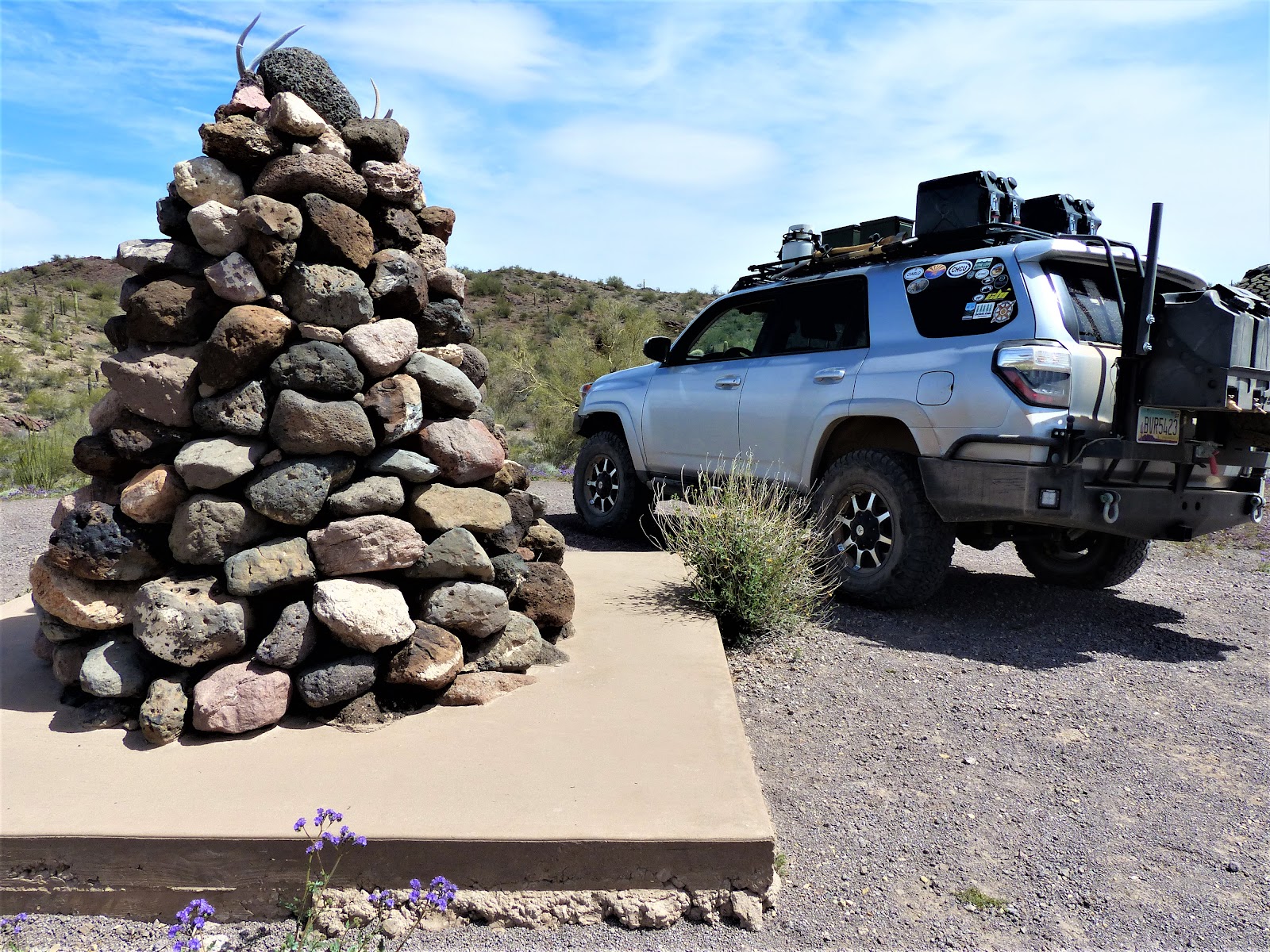
South of Kofa cabin Wilbanks Road stays mostly in the sandy, and occasionally rocky, bottom of Alamo Wash. I followed it few miles, passing a rocky butte named Owl Head and navigating a couple of tight spots, to visit the Kofa Monument, a cemented pyramid of stones with a brass plaque commemorating the establishment of Kofa as a National Wildlife Refuge by Presidential order in 1939. The setting was nice, remote, quiet lots of jagged rock outcroppings around.

Backtracking north and then east to check out Charco 4, an old well with a working windmill. The refuge maintains the windmill to feed a water trough for the local wildlife. Farther east, Hovatter Road angled south through BLM land eventually fishhooking west and back into the Kofa Preserve. Hovatter was pretty well maintained down to the Crowder Dam, a long earthen levee anchored against Coyote Peak that trapped the flow of a wide shallow wash to provide seasonal water and improved cattle grazing on leased BLM land. Bob Crowder was one of the first cattlemen in the area. A small monument near the dam touted his influence in the area.
Beyond Crowder Dam, Hovatter Road became a very basic two track, weeds slapping the front bumper as we pushed into the Little Horn Mountains. While still easy driving, a welcome feeling of remoteness settled in. The unusually wet Winter left the early Spring desert obscenely lush. Wildflowers sprang up everywhere; gold, purple, white, orange, yellow. Ocotillo branches ended in red flowers. Pale green cholla flushed with hundreds of spines silver in the afternoon sun. Royal crimson buds dotted gardens of prickly pear cactus. The side of a ridgeline made of black boulders flashed kelly green stripes along water drainages, intense enough to match anything in Ireland, brazen against the black matte of the hill. In a few weeks the green stripes will morph into canvas tan, the magic gone. Topping an elevated pass on a rocky hogback, a stretch so amazingly lush for such an austere desert caused me to stop and stare in simple wonderment. How green is your valley I asked noone.


South of the Little Horns is the Hovatter homestead site. The Hovatter family lived here from 1951 to 1973. All that remains of the homestead are the cactus gardens, rows of saguaro cacti lining the curved driveway. The Hovatters had mining claims for manganese in the surrounding mountains. On a knoll above the site, Ray Hovatter (1897 - 1974) and his stepdaughter Lindsay (1944 - 1968) lie in marked graves. The Hovatter matriarch, Barbara, died in 1992 in the little town of Aguila hours before her 82nd birthday. Her ashes were scattered on the two graves. The Hovatter site is a peaceful setting, the large flat area of the homestead a nice spot for a large group to camp. I was tempted, but there were still a few hours of daylight.

Late afternoon led to the Hoodoo cabin, a former line shack for the Crowder - Weisser Cattle Company. The cabin was built around 1940 from a kit, the parts labeled with brass medallions to assist with assembly. The cabin was spacious, furnished, a somewhat modern bathroom, now useless without running water, spacious kitchen. One wall had hinged outside “scales” that could be lifted up via inside ropes attached to outside pulleys thus turning the entire sidewall of the room into studs and wire screen, a neat trick on warm summer evenings.

Walking through the cabin, it seemed my tinnitus had kicked into overdrive, a constant buzzing in my ears. The sound was worse, louder, in the kitchen. Or maybe it was bees. Bees in the walls? A hive? Checked outside. Yep. North wall. Time to move away and make camp.
A windmill sits on the edge of of Hoodoo Wash near the cabin, pumping water into yet another game trough. I set up camp well away to avoid interference with nocturnal wildlife watering. Burgers were on tonight’s menu, thick patties, onion, tomato, baked beans, the Sun Chips I love, a cold and generously poured libation in accompaniment. As the burgers sizzled, my newly crafted bug screens went up on the 4Runner’s rear windows. The evening was warm and various insects were looking to feed, mostly on me. Since I was sleeping in the truck this trip, the screens were essential. A beautiful sunset provided backdrop to a good meal.

Besides the window screens, two other new items were getting a shake down on this trip. A new RAM mount had been holding my iPad securely in place all day to help with navigation via the Gaia app. That addition was proving a total touchdown. My phone, rather useless out here, had a new app. Libby used my library membership to download audio books. I sat in camp under a star strewn sky listening to a soothing voice tell me a story. I’d finish the book before completing the trip. Lesson learned. Download more than one book.
With a quick breakfast done and a couple of tumblers of hot coffee in Bullit’s cup holders, we set out for the third cabin of the trip. Eight miles up Hoodoo Wash was Wilbank’s Cabin. The drive was easy enough until about a mile to go. The sandy wash turned rocky, bedrock and boulders for a hundred yards. While I thought Bullit was capable of getting through the obstacle, a single mistake could leave me high centered and helplessly stranded. If there was a second vehicle or even a good spotter with us, then I’d definitely enjoy trying my hand at getting through the rock maze. But the nice morning deserved a walk, so I parked the truck and grabbed a small pack. Days later, looking at satellite imagery, I discovered there is an easy bypass around the obstacle along the north side of the wash.
Two Razor ATVs were parked at Wilbanks, one at each end of the porch. Some gear was stacked near the front door. There were no sounds or movement. I explored around hoping, to no avail, that someone might notice. Maybe then I could get a peek inside the cabin. I assume they were all sleeping very very well inside. The nearby windmill fed yet another wildlife water trough from the Wilbank’s well. I hiked back to the truck.

Back at Hoodoo Cabin, we turned south on Kofa Manganese Road. For the next five or so miles the road alternately crept along the side or down in the middle of the rambling and overgrown Hoodoo Wash. It was the worst road yet. I didn’t shed a tear when it turned wet and began a rocky climb into the rugged Kofa Mountains. A hard left south along a thin bumpy two track connected us with Engesser Road and up Engesser Pass with its long views. The elevated pass made for a good lunch stop. Although the temperatures were in the high 70s, the midday sun was brutal. I ate in the sliver of shade of the north side of the truck, no other spot nearby offering any relief given the sparse vegetation.

After a steep descent, Engesser Road turns north along the western edge of the Kofa Mountains towards the mine that gives the area its name. I was keen to see the famed King of Arizona Mine. The NO TRESPASSING sign and thick chain across the road told me I wouldn’t. I settled for hiking over to the Kofa cemetery, which according to the Arizona Pioneer and Cemetery Project has 13 marked graves with the youngest buried there an infant and the oldest, Pasquala Rameriz, aged 100 years. There may be as many as 200 additional unmarked graves at the site. The cemetery is fenced, though part of that is falling down. Only one grave has a headstone and it is in heavily weathered Spanish. Known burials were all between 1907 and 1911, obviously the height of mining activity in the area.

The map shows a dam just north of the prominent Kofa Butte. A narrow overgrown two-track goes part way. I drove to the end of the little trail and loaded a couple of bottles of water and my camera in a pack. The way up is a sort of a trail beginning where Kofa Dam Wash empties into Yaqui Wash. I was wearing shorts given the warm day. Not a great idea. Acacia and other thorny shrubs left their bloody marks as I pushed through the areas of heavier growth in the wash. Flowers were everywhere. Bees too, but so intent were they on enjoying the short-lived riot of pollen the late spring that they offered no notice of my passing.
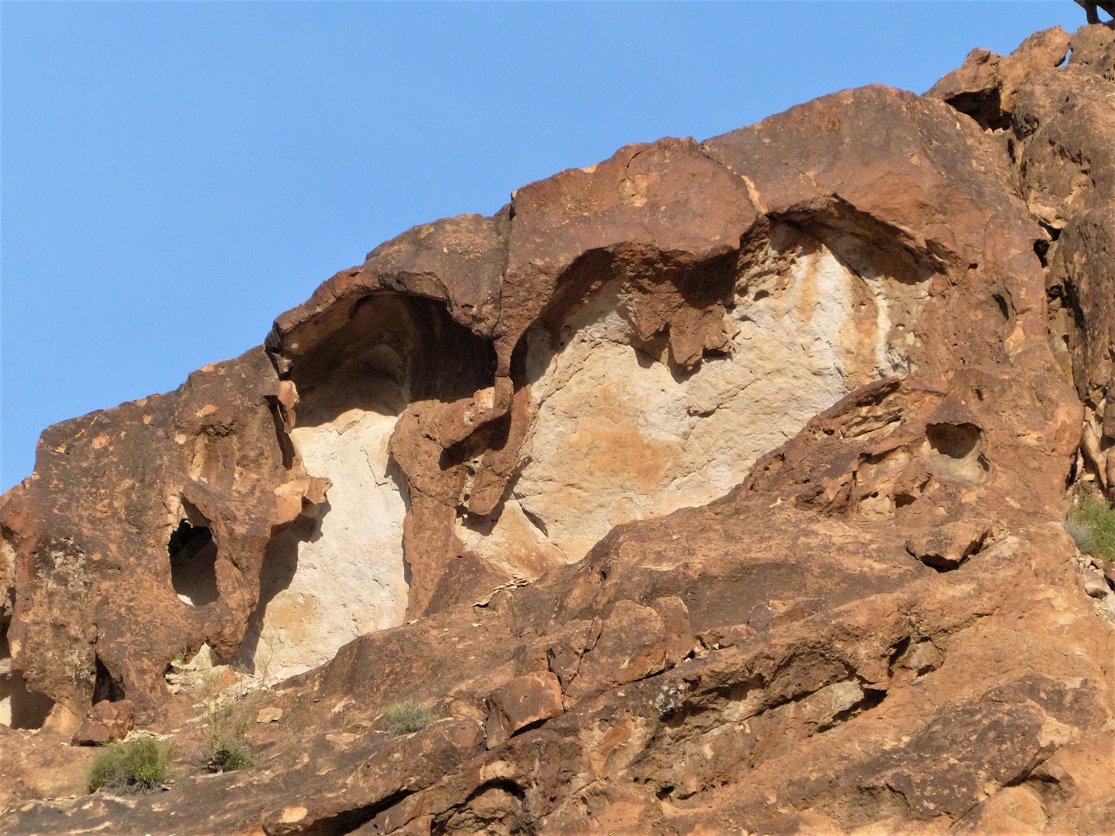
The walls of the canyon were steep, dark bare rock littered with caves, windows, arches, sharply pointed spires. These are new mountains, geologically speaking, not the gentle undulating comfortable sedimentary sandstone of southern Utah that I love. This is rock formed by unfathomable heat and pressure, metamorphic, violently pushed through the mantle of the earth from its melted core, cooling into phantasmic shapes, too young to have been weathered smooth and stripped of their Vulcanic magnificence. The uplift had brought along the exotic minerals formed only in the earth’s core; small veins of gold, silver, manganese. These rare minerals attracted the miners who built a large concrete dam somewhere up a steep drainage ahead.


The dam was marked on the Gaia app on my phone, an underlying detailed topographic map. Knowing the dam was close, a peek at the map showed me one drainage too far south having chosen unwisely when the correct drainage looked impassable due to some very high spillovers. I backtracked a few hundred feet and then left the wash, attempting a higher approach to the dam. Scrambling up, around and over the ridge between the two washes, the coarse rock provided good hand and footholds. Gloves would have been useful. The climb ended on a perch above the dam. There was no lake behind the dam, only a very green pasture. Over the decades, the violent run off of the infrequent rains filled in the area behind the dam with silt, no doubt to the consternation of the miners but now providing welcome grazing for desert sheep and deer as attested by the numerous criss crossing game trails.

I clambered down into the drainage below the dam. The ends of the dam are anchored in the bedrock walls of a narrow space of the canyon, maybe 30 feet high, made of concrete and stone with a pronounced curve into the upstream side. A rusty cable ran from one side of the canyon to the other, a pulley hanging midway. A two-inch pipe ran along the wash, the conduit of precious water the former mining community far below. I followed it down wash until it plunged over a 20-foot slick rock pour off with a rock pool below filled with water. Looking further down there seemed another pour off. The only way down was back up, retracing my original entry.


There are numerous other mines in the vicinity. I had planned to spend some time exploring around them and even spending the night in the area. Numerous “private property” and “no trespassing” signs, some with very colorful additional language, gave the whole area a decidedly unwelcoming atmosphere. Even though the sun was getting low, I opted to cross the wide flat King Valley to camp in the Castle Dome Mountains further west.
A flat spot with nice views and near my next day’s hike made for the perfect campsite. Dinner was my version of camp pizza, a tortilla, some pesto, Italian sausage and mushrooms cooked before I left home, sun dried tomatoes, some Italian seasonings and lots of shredded mozzarella. The assembled pizza placed on a griddle and then popped into my little Weber grill. The result won’t win awards at a culinary festival, but it tastes great in a lonely camp set against some low hills looking down onto a broad valley.

Two washes passed my camp on opposite sides. The day would be spent exploring both. The first was labeled Horse Tanks on the map. After breakfast I went up the wash and soon found pools of water, tanks in local parlance, tinajas if you live further south. An amphitheater of surrounding mostly bare rock hills sheds the infrequent rain, funnelling it into steepness slots creating a rushing sand laden torrent which carves out rock pools below waterfalls. The pools, often shaded in the deeply carved watercourses, hold hundreds and sometimes thousands of gallons of water for long periods. A fan of three individual drainages fed down into the main wash. Two of those had numerous tanks, small and large, some holding as much as my swimming pool did at home. I climbed easy on the rocks above the narrow slot of the water courses until the slope got uncomfortably steep and exposed. After a bit I just stopped counting the tanks. Toads swam away on my approach, hiding wherever they could.


The desert bighorns knew how many tanks were here, their dried marbles of scat scattered widely on the bare rock. Desert sheep can drink nearly 20 percent of their body weight in water at one time. They physically swell to accommodate the precious liquid, which allows them to go at least four days without watering even in the harshest summer heat, thus increasing their range for foraging in the resource limited desert. Deer can’t do that, so they have to remain near the water sources to drink more often and are scarce in this part of the Sonoran Desert.

Where sand and silt had created a foothold for plant life, xeriscape gardens flourished, fed by the recent wet winter. Flowers bloomed in an array of bright colors, cacti thrived, hardy desert grasses bent in the breeze, a variety of agave species pointed their daggers up and out. Orange wolfberries made for a tart mid morning snack.
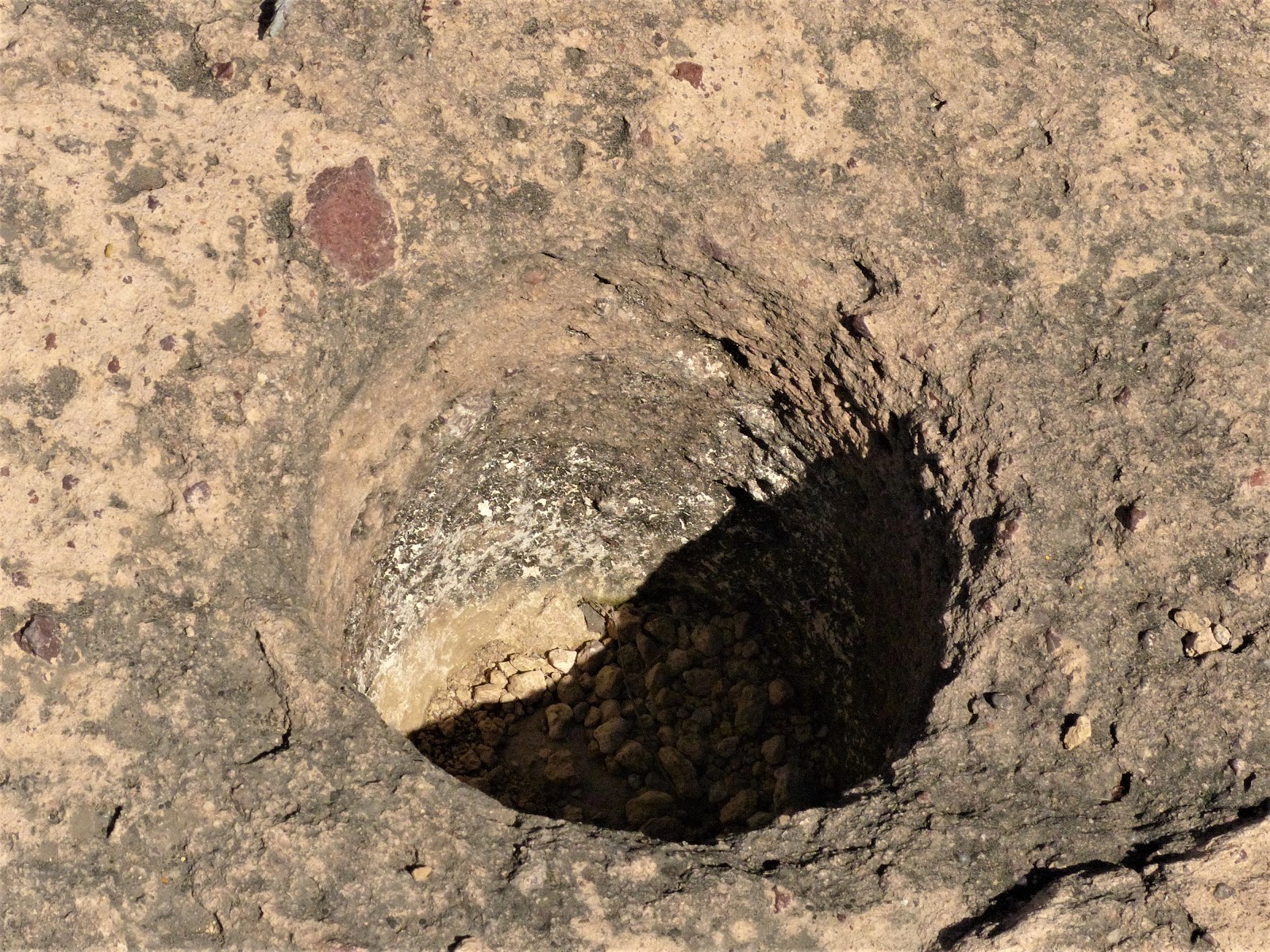
Plants and animals weren’t the only ones with knowledge of the tanks. I knew from research there were signs of human activity around, thousands of years old. But I wasn’t having any luck finding it. Finally, as I climbed down, thinking to head back to camp before the day got too hot grind holes emerged in the bedrock of the lower wash. Perfectly circular, ten to twelve inches in diameter and often more than a foot deep, these morteros were used to grind dried seeds and beans. Much smaller morteros, only two inches wide were also nearby. I’m not sure why the dramatic difference in size or the purpose of the smaller ones.
Leaving the morteros, I happened to glance at a flat faced boulder near the mouth of the canyon. ‘E.W. 11/1/1928’ was chipped into the desert varnish in large block letters. I cut over to check it out only to find E.W had cut his message into a panel of geometric petroglyphs so faint as to be easily missed at a distance. Parallel wavy vertical lines were the predominant shape cut into the rock, the message of flowing water unmistakable. Not many canyons in the Kofa host tanks. This ancient billboard announced to all travelers that this canyon did.

Back in camp the harsh sun demanded the deployment of Bullit’s shade canopy. I staked it securely lest an errant wind gust turn it into a sail. Lunch, the warm breeze and the audiobook set my eyelids to drooping. With the windows open to the breeze, the sleeping platform in the truck provided accomodation for a couple hours of napping and contemplation.
Late afternoon provided opportunity to explore Gray Tanks Wash. From the topo map I knew to head east first, drop into the correct wash and proceed south. Not far from camp was an alcove 70 feet above the desert floor in a small bluff. I climbed up for a look, discovering a dozen grinding holes in the rock floor, most considerably larger and deeper than the ones from the morning. The alcove was high enough to stand erect and offered a fantastic view across King Valley. Nearby a small panel of glyphs had faded beyond easy recognition. Obviously this area was a seasonal camp visited over and over for a long time.


From the alcove I dropped down into the wash and headed up to Gray Tanks. Small water filled potholes dotted the solid rock bed of the wash with a few additional morteros. A short climb along the drainage led to the first of many large tanks. Sitting above one of the larger I took in the whole of the area. The surrounding cliffs were of differing rock layers, much of it granite, with a wide range of colors. Umber layered above cream. One cliffside had eroded so as to look like one of the ant farms kids used to have, the tunneling and rooms of the ants visible through the glass. Rust knolls emerging from more eroded areas lower down the valley. Black basalt up high had scattered broken boulders helter skelter down a slope fanning out into the plain of the wash, erosion and gravity already seeking to grind down the new mountains and return their sand and pebbles to the sea, nature eternally seeking seeking balance.


The day had cooled nicely by the time I made it back to camp. Tonight was a good steak, little single serving cans of baked beans and peas and carrots heated alongside the steak as it grilled. A good beverage and the last of the audio book accompanied the meal, the last sun rays highlighting the alcove above camp. With camp cleaned and secured, I watched the emergence of the stars, the sky so dark the bloom of Phoenix’s faraway lights evident in the eastern sky. Even Yuma’s meager lights cast a gentle glow to the south.
With just a quick breakfast, camp came down quickly. The drive out to Highway 95 passed several groups of campers, the size of the associated rigs increasing in size as the distance to pavement decreased. I aired up the tires not far from a massive condominium on wheels, no signs of life around it, but the day was still an infant.
While researching the trip, I’d seen a unique man-made spiral just off the road to Palm Canyon on satellite imagery. Pulling up alongside the ….what? piece of rock art? class project? results of boredom from an energetic winter visitor with their RV parked nearby for weeks? Where ever it came from, the effort was admirably perfect, the black rocks of the flat playa scraped into perfect windrows revealing the lighter clay below, the center pivot a cluster of larger rocks and various colors of glass bottles. Pull up Google Maps on your computer, select the satellite view, and enter N33° 22.395' W114° 10.430' in the search box (or just follow the link embedded in the coordinates).

The hike up Palm Canyon is impressive, not for the small grove of palms, but for the soaring escarpments of the canyon walls. You’d think days of amazing geology would render you immune to staring open mouthed. Maybe you, but not me.


With fuel running low, we headed into Quartzsite, the little town’s population plummeting as temperatures rise, the winter residents firing up their RVs and headed back north in what has become a massive human seasonal migration. There were still plenty parked in every flat spot along Highway 95 south of Quartzsite.
Dripping Springs, at the base of a large granite peak in the New Water Mountains along the northern edge of the Kofa, has water. It was reasonably on the way home, well sort of. I left Interstate 10 at the Gold Nugget exit and aired down again. I stopped at what had been an old miner’s stone cabin. The rear eave hosted a satellite dish. Laundry hung from a clothesline. A fire ring out front looked recently used. I kept a distance and hailed the house. No one answered. I approached slowly, armed with my camera in case I needed to shoot anything or anyone. A poorly dug grave gave me pause and then laughter. Apparently the local ATV crowd hangs out here and was responsible for the very diverse, and not so politically correct, contents of the grounds and cabin interior.


There was some doubt in my mind about the best way to Dripping Springs from the BLM road to the erstwhile miner cabin. I’m still not sure I took the best way, though it may be the only way. Either way, the extremely interesting drive featured washes narrow and steep-sided leaving only a couple of inches clearance on either side of my truck windows followed by long steep climbs which obviously became steep descents on the way out, all combined with interesting rock obstacles thrown in at random intervals. You certainly didn’t want to meet anyone coming in the opposite direction. Luckily I didn’t.
The payoff was a small spring and associated oasis. The drainage from the spring was overgrown for short distance. Beyond were numerous rock panels filled with petroglyphs, both ancient and recent. Among the recent were some dated from the early 1800s, most likely explorers coming in from California. Ones with dates in the middle 1800s could have come in from either direction. ANN used large letters but left no date.

The ancient glyphs were both geometric and anthropomorphic. Archeologists theorize all petroglyphs along the lower Colorado River were originally geometric, with anthropomorphic and zoomorphic glyphs appearing more recently, perhaps the last 1500 years. My impression was the area had been used for a very long time by early inhabitants, European explorers and modern day visitors like me. We have all left our mark. I left nothing but tire and foot prints and took nothing but photos and a small handful of wolfberries.
After over 200 miles of sometimes demanding dirt driving, the easy road home provided time to reflect. Kofa was vast, beautiful in both its current outbreak of growth and color and greenery as well as its manic up thrusts of rocky peaks. Summer it would be dry, stark, even desolate in the Sonoran heat with vast areas essentially unbearable, uninhabitable. But in small pockets there would still be water and thus life through natural springs and the wells and windmills of early settlers. The mountains had concentrated valuable minerals in some areas, but they were not widespread.
The Kofa had for centuries been at least a part time home for humans, natives escaping the spring floods of the unchecked Colorado into the canyons they knew to have water and edibles. Miners and cattlemen coming to the area to tap its wealth when towns in the Southwest held only a small percentage of the overall population. Today the cities hold almost all of the region’s population and no one lives in the Kofa except escapees from northern winters along the extreme edges where paved roads and flat spaces make travel easy and parkas are not required. Other tethered nomads, like me, occasionally wander through in curiosity, exploration, but little more. Vast as it is, stark and desolate as it can be, Kofa has always provided concentrated abundance in small secreted areas for its animals to live, for a variety of peoples to come and go.

Kofa is part wildlife refuge, part BLM land with tiny plots of patented mining claims and a few designated wilderness areas thrown in. It is bordered on the south by a bombing and test range for Yuma Marine Corps Air Station, the east by more BLM land and a lot of not much. The west side has Highway 95 running east of the Colorado River between Yuma and Quartzsite. It is rugged desert and low mountains, cut by only a few dirt roads and unmaintained two-tracks. The wildlife refuge has a website but without much real information. In truth, there is a dearth of information about the area. Perfect!
Bullit’s fuel tanks got topped up at the Chevron at I-10 and Vicksburg Road. Fuel would be an nagging issue since I had several days of travel ahead on trails of unknown quality and no chance at more petrol. Fuel calculations would occupy my thoughts until I got to Quartzsite, 4 days later. The deflators brought tire pressures down to 18 in the front and 20 in the heavier rear to improve the ride, minimize punctures, and increase traction.
Vicksburg Road turns into nicely graded dirt south of the Interstate. A roadside kiosk had information on the flora and fauna of the area. A container held slick folded pamphlets with a rudimentary map on one side and extensive regulations for using the area on the other. It also provided life saving words for morons. ‘Rock climbing is hazardous.’ Who knew? I could have used more map and less words.
Went west at the Pipeline Road and then south on Wilbanks Road to find the Kofa cabin. The area has at least three cabins that can be used by visitors on a first come, first served basis. Despite no intentions of bunking at any of the cabins, I still wanted to see them. The Kofa cabin is a stone and mortar affair built by the Civilian Conservation Corps in the 1930s. The drive was easy and I had to laugh at all the provisions folks had left in the cabin for future visitors -- canned goods, books, water, cookware, mostly empty liquor bottles, and a log book for visitors to sign. A wood burning stove and two metal cots stood towards the back of the cabin, just needing your sleeping pad and bedding to make for a cozy night. A few chairs and a table rounded out the furnishings. A broom and dustpan in a corner reminded everyone that cleanliness is next to not sleeping with spiders.
South of Kofa cabin Wilbanks Road stays mostly in the sandy, and occasionally rocky, bottom of Alamo Wash. I followed it few miles, passing a rocky butte named Owl Head and navigating a couple of tight spots, to visit the Kofa Monument, a cemented pyramid of stones with a brass plaque commemorating the establishment of Kofa as a National Wildlife Refuge by Presidential order in 1939. The setting was nice, remote, quiet lots of jagged rock outcroppings around.
Backtracking north and then east to check out Charco 4, an old well with a working windmill. The refuge maintains the windmill to feed a water trough for the local wildlife. Farther east, Hovatter Road angled south through BLM land eventually fishhooking west and back into the Kofa Preserve. Hovatter was pretty well maintained down to the Crowder Dam, a long earthen levee anchored against Coyote Peak that trapped the flow of a wide shallow wash to provide seasonal water and improved cattle grazing on leased BLM land. Bob Crowder was one of the first cattlemen in the area. A small monument near the dam touted his influence in the area.
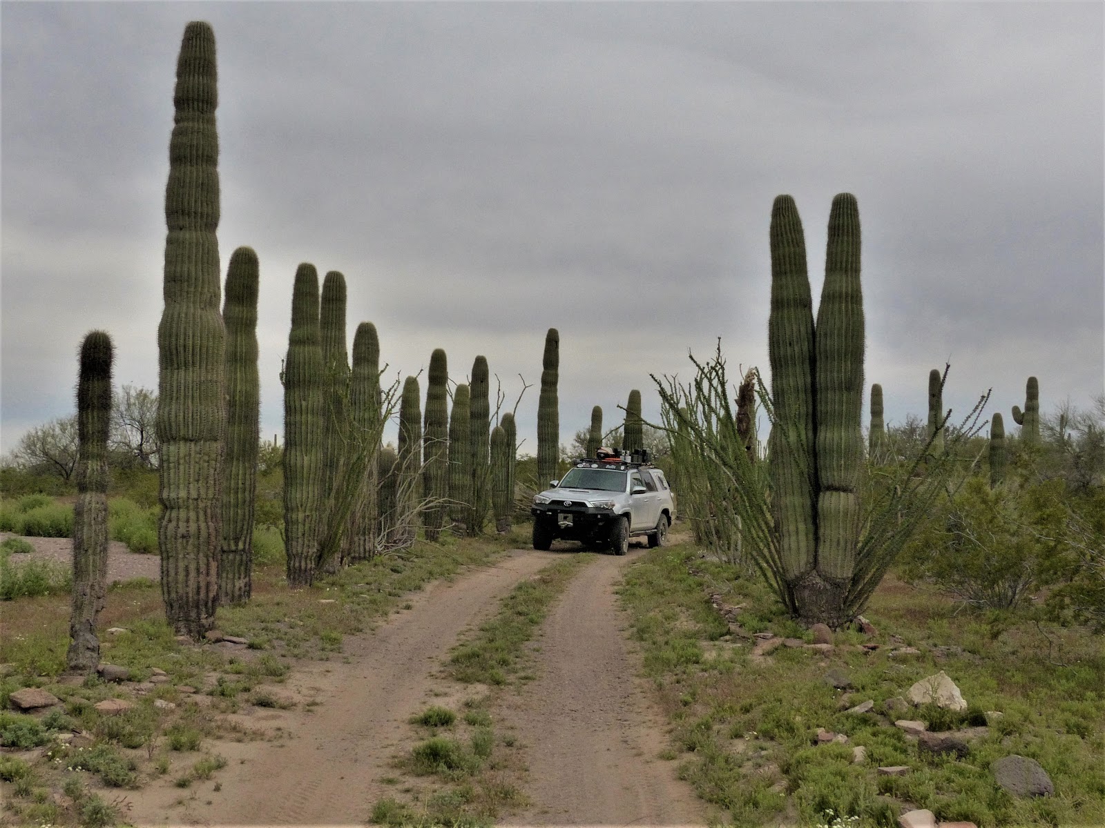
Beyond Crowder Dam, Hovatter Road became a very basic two track, weeds slapping the front bumper as we pushed into the Little Horn Mountains. While still easy driving, a welcome feeling of remoteness settled in. The unusually wet Winter left the early Spring desert obscenely lush. Wildflowers sprang up everywhere; gold, purple, white, orange, yellow. Ocotillo branches ended in red flowers. Pale green cholla flushed with hundreds of spines silver in the afternoon sun. Royal crimson buds dotted gardens of prickly pear cactus. The side of a ridgeline made of black boulders flashed kelly green stripes along water drainages, intense enough to match anything in Ireland, brazen against the black matte of the hill. In a few weeks the green stripes will morph into canvas tan, the magic gone. Topping an elevated pass on a rocky hogback, a stretch so amazingly lush for such an austere desert caused me to stop and stare in simple wonderment. How green is your valley I asked noone.
South of the Little Horns is the Hovatter homestead site. The Hovatter family lived here from 1951 to 1973. All that remains of the homestead are the cactus gardens, rows of saguaro cacti lining the curved driveway. The Hovatters had mining claims for manganese in the surrounding mountains. On a knoll above the site, Ray Hovatter (1897 - 1974) and his stepdaughter Lindsay (1944 - 1968) lie in marked graves. The Hovatter matriarch, Barbara, died in 1992 in the little town of Aguila hours before her 82nd birthday. Her ashes were scattered on the two graves. The Hovatter site is a peaceful setting, the large flat area of the homestead a nice spot for a large group to camp. I was tempted, but there were still a few hours of daylight.
Late afternoon led to the Hoodoo cabin, a former line shack for the Crowder - Weisser Cattle Company. The cabin was built around 1940 from a kit, the parts labeled with brass medallions to assist with assembly. The cabin was spacious, furnished, a somewhat modern bathroom, now useless without running water, spacious kitchen. One wall had hinged outside “scales” that could be lifted up via inside ropes attached to outside pulleys thus turning the entire sidewall of the room into studs and wire screen, a neat trick on warm summer evenings.
Walking through the cabin, it seemed my tinnitus had kicked into overdrive, a constant buzzing in my ears. The sound was worse, louder, in the kitchen. Or maybe it was bees. Bees in the walls? A hive? Checked outside. Yep. North wall. Time to move away and make camp.
A windmill sits on the edge of of Hoodoo Wash near the cabin, pumping water into yet another game trough. I set up camp well away to avoid interference with nocturnal wildlife watering. Burgers were on tonight’s menu, thick patties, onion, tomato, baked beans, the Sun Chips I love, a cold and generously poured libation in accompaniment. As the burgers sizzled, my newly crafted bug screens went up on the 4Runner’s rear windows. The evening was warm and various insects were looking to feed, mostly on me. Since I was sleeping in the truck this trip, the screens were essential. A beautiful sunset provided backdrop to a good meal.
Besides the window screens, two other new items were getting a shake down on this trip. A new RAM mount had been holding my iPad securely in place all day to help with navigation via the Gaia app. That addition was proving a total touchdown. My phone, rather useless out here, had a new app. Libby used my library membership to download audio books. I sat in camp under a star strewn sky listening to a soothing voice tell me a story. I’d finish the book before completing the trip. Lesson learned. Download more than one book.
With a quick breakfast done and a couple of tumblers of hot coffee in Bullit’s cup holders, we set out for the third cabin of the trip. Eight miles up Hoodoo Wash was Wilbank’s Cabin. The drive was easy enough until about a mile to go. The sandy wash turned rocky, bedrock and boulders for a hundred yards. While I thought Bullit was capable of getting through the obstacle, a single mistake could leave me high centered and helplessly stranded. If there was a second vehicle or even a good spotter with us, then I’d definitely enjoy trying my hand at getting through the rock maze. But the nice morning deserved a walk, so I parked the truck and grabbed a small pack. Days later, looking at satellite imagery, I discovered there is an easy bypass around the obstacle along the north side of the wash.
Two Razor ATVs were parked at Wilbanks, one at each end of the porch. Some gear was stacked near the front door. There were no sounds or movement. I explored around hoping, to no avail, that someone might notice. Maybe then I could get a peek inside the cabin. I assume they were all sleeping very very well inside. The nearby windmill fed yet another wildlife water trough from the Wilbank’s well. I hiked back to the truck.
Back at Hoodoo Cabin, we turned south on Kofa Manganese Road. For the next five or so miles the road alternately crept along the side or down in the middle of the rambling and overgrown Hoodoo Wash. It was the worst road yet. I didn’t shed a tear when it turned wet and began a rocky climb into the rugged Kofa Mountains. A hard left south along a thin bumpy two track connected us with Engesser Road and up Engesser Pass with its long views. The elevated pass made for a good lunch stop. Although the temperatures were in the high 70s, the midday sun was brutal. I ate in the sliver of shade of the north side of the truck, no other spot nearby offering any relief given the sparse vegetation.
After a steep descent, Engesser Road turns north along the western edge of the Kofa Mountains towards the mine that gives the area its name. I was keen to see the famed King of Arizona Mine. The NO TRESPASSING sign and thick chain across the road told me I wouldn’t. I settled for hiking over to the Kofa cemetery, which according to the Arizona Pioneer and Cemetery Project has 13 marked graves with the youngest buried there an infant and the oldest, Pasquala Rameriz, aged 100 years. There may be as many as 200 additional unmarked graves at the site. The cemetery is fenced, though part of that is falling down. Only one grave has a headstone and it is in heavily weathered Spanish. Known burials were all between 1907 and 1911, obviously the height of mining activity in the area.
The map shows a dam just north of the prominent Kofa Butte. A narrow overgrown two-track goes part way. I drove to the end of the little trail and loaded a couple of bottles of water and my camera in a pack. The way up is a sort of a trail beginning where Kofa Dam Wash empties into Yaqui Wash. I was wearing shorts given the warm day. Not a great idea. Acacia and other thorny shrubs left their bloody marks as I pushed through the areas of heavier growth in the wash. Flowers were everywhere. Bees too, but so intent were they on enjoying the short-lived riot of pollen the late spring that they offered no notice of my passing.
The walls of the canyon were steep, dark bare rock littered with caves, windows, arches, sharply pointed spires. These are new mountains, geologically speaking, not the gentle undulating comfortable sedimentary sandstone of southern Utah that I love. This is rock formed by unfathomable heat and pressure, metamorphic, violently pushed through the mantle of the earth from its melted core, cooling into phantasmic shapes, too young to have been weathered smooth and stripped of their Vulcanic magnificence. The uplift had brought along the exotic minerals formed only in the earth’s core; small veins of gold, silver, manganese. These rare minerals attracted the miners who built a large concrete dam somewhere up a steep drainage ahead.
The dam was marked on the Gaia app on my phone, an underlying detailed topographic map. Knowing the dam was close, a peek at the map showed me one drainage too far south having chosen unwisely when the correct drainage looked impassable due to some very high spillovers. I backtracked a few hundred feet and then left the wash, attempting a higher approach to the dam. Scrambling up, around and over the ridge between the two washes, the coarse rock provided good hand and footholds. Gloves would have been useful. The climb ended on a perch above the dam. There was no lake behind the dam, only a very green pasture. Over the decades, the violent run off of the infrequent rains filled in the area behind the dam with silt, no doubt to the consternation of the miners but now providing welcome grazing for desert sheep and deer as attested by the numerous criss crossing game trails.
I clambered down into the drainage below the dam. The ends of the dam are anchored in the bedrock walls of a narrow space of the canyon, maybe 30 feet high, made of concrete and stone with a pronounced curve into the upstream side. A rusty cable ran from one side of the canyon to the other, a pulley hanging midway. A two-inch pipe ran along the wash, the conduit of precious water the former mining community far below. I followed it down wash until it plunged over a 20-foot slick rock pour off with a rock pool below filled with water. Looking further down there seemed another pour off. The only way down was back up, retracing my original entry.
There are numerous other mines in the vicinity. I had planned to spend some time exploring around them and even spending the night in the area. Numerous “private property” and “no trespassing” signs, some with very colorful additional language, gave the whole area a decidedly unwelcoming atmosphere. Even though the sun was getting low, I opted to cross the wide flat King Valley to camp in the Castle Dome Mountains further west.
A flat spot with nice views and near my next day’s hike made for the perfect campsite. Dinner was my version of camp pizza, a tortilla, some pesto, Italian sausage and mushrooms cooked before I left home, sun dried tomatoes, some Italian seasonings and lots of shredded mozzarella. The assembled pizza placed on a griddle and then popped into my little Weber grill. The result won’t win awards at a culinary festival, but it tastes great in a lonely camp set against some low hills looking down onto a broad valley.
Two washes passed my camp on opposite sides. The day would be spent exploring both. The first was labeled Horse Tanks on the map. After breakfast I went up the wash and soon found pools of water, tanks in local parlance, tinajas if you live further south. An amphitheater of surrounding mostly bare rock hills sheds the infrequent rain, funnelling it into steepness slots creating a rushing sand laden torrent which carves out rock pools below waterfalls. The pools, often shaded in the deeply carved watercourses, hold hundreds and sometimes thousands of gallons of water for long periods. A fan of three individual drainages fed down into the main wash. Two of those had numerous tanks, small and large, some holding as much as my swimming pool did at home. I climbed easy on the rocks above the narrow slot of the water courses until the slope got uncomfortably steep and exposed. After a bit I just stopped counting the tanks. Toads swam away on my approach, hiding wherever they could.
The desert bighorns knew how many tanks were here, their dried marbles of scat scattered widely on the bare rock. Desert sheep can drink nearly 20 percent of their body weight in water at one time. They physically swell to accommodate the precious liquid, which allows them to go at least four days without watering even in the harshest summer heat, thus increasing their range for foraging in the resource limited desert. Deer can’t do that, so they have to remain near the water sources to drink more often and are scarce in this part of the Sonoran Desert.
Where sand and silt had created a foothold for plant life, xeriscape gardens flourished, fed by the recent wet winter. Flowers bloomed in an array of bright colors, cacti thrived, hardy desert grasses bent in the breeze, a variety of agave species pointed their daggers up and out. Orange wolfberries made for a tart mid morning snack.
Plants and animals weren’t the only ones with knowledge of the tanks. I knew from research there were signs of human activity around, thousands of years old. But I wasn’t having any luck finding it. Finally, as I climbed down, thinking to head back to camp before the day got too hot grind holes emerged in the bedrock of the lower wash. Perfectly circular, ten to twelve inches in diameter and often more than a foot deep, these morteros were used to grind dried seeds and beans. Much smaller morteros, only two inches wide were also nearby. I’m not sure why the dramatic difference in size or the purpose of the smaller ones.
Leaving the morteros, I happened to glance at a flat faced boulder near the mouth of the canyon. ‘E.W. 11/1/1928’ was chipped into the desert varnish in large block letters. I cut over to check it out only to find E.W had cut his message into a panel of geometric petroglyphs so faint as to be easily missed at a distance. Parallel wavy vertical lines were the predominant shape cut into the rock, the message of flowing water unmistakable. Not many canyons in the Kofa host tanks. This ancient billboard announced to all travelers that this canyon did.
Back in camp the harsh sun demanded the deployment of Bullit’s shade canopy. I staked it securely lest an errant wind gust turn it into a sail. Lunch, the warm breeze and the audiobook set my eyelids to drooping. With the windows open to the breeze, the sleeping platform in the truck provided accomodation for a couple hours of napping and contemplation.
Late afternoon provided opportunity to explore Gray Tanks Wash. From the topo map I knew to head east first, drop into the correct wash and proceed south. Not far from camp was an alcove 70 feet above the desert floor in a small bluff. I climbed up for a look, discovering a dozen grinding holes in the rock floor, most considerably larger and deeper than the ones from the morning. The alcove was high enough to stand erect and offered a fantastic view across King Valley. Nearby a small panel of glyphs had faded beyond easy recognition. Obviously this area was a seasonal camp visited over and over for a long time.
From the alcove I dropped down into the wash and headed up to Gray Tanks. Small water filled potholes dotted the solid rock bed of the wash with a few additional morteros. A short climb along the drainage led to the first of many large tanks. Sitting above one of the larger I took in the whole of the area. The surrounding cliffs were of differing rock layers, much of it granite, with a wide range of colors. Umber layered above cream. One cliffside had eroded so as to look like one of the ant farms kids used to have, the tunneling and rooms of the ants visible through the glass. Rust knolls emerging from more eroded areas lower down the valley. Black basalt up high had scattered broken boulders helter skelter down a slope fanning out into the plain of the wash, erosion and gravity already seeking to grind down the new mountains and return their sand and pebbles to the sea, nature eternally seeking seeking balance.
The day had cooled nicely by the time I made it back to camp. Tonight was a good steak, little single serving cans of baked beans and peas and carrots heated alongside the steak as it grilled. A good beverage and the last of the audio book accompanied the meal, the last sun rays highlighting the alcove above camp. With camp cleaned and secured, I watched the emergence of the stars, the sky so dark the bloom of Phoenix’s faraway lights evident in the eastern sky. Even Yuma’s meager lights cast a gentle glow to the south.
With just a quick breakfast, camp came down quickly. The drive out to Highway 95 passed several groups of campers, the size of the associated rigs increasing in size as the distance to pavement decreased. I aired up the tires not far from a massive condominium on wheels, no signs of life around it, but the day was still an infant.
While researching the trip, I’d seen a unique man-made spiral just off the road to Palm Canyon on satellite imagery. Pulling up alongside the ….what? piece of rock art? class project? results of boredom from an energetic winter visitor with their RV parked nearby for weeks? Where ever it came from, the effort was admirably perfect, the black rocks of the flat playa scraped into perfect windrows revealing the lighter clay below, the center pivot a cluster of larger rocks and various colors of glass bottles. Pull up Google Maps on your computer, select the satellite view, and enter N33° 22.395' W114° 10.430' in the search box (or just follow the link embedded in the coordinates).
The hike up Palm Canyon is impressive, not for the small grove of palms, but for the soaring escarpments of the canyon walls. You’d think days of amazing geology would render you immune to staring open mouthed. Maybe you, but not me.
With fuel running low, we headed into Quartzsite, the little town’s population plummeting as temperatures rise, the winter residents firing up their RVs and headed back north in what has become a massive human seasonal migration. There were still plenty parked in every flat spot along Highway 95 south of Quartzsite.
Dripping Springs, at the base of a large granite peak in the New Water Mountains along the northern edge of the Kofa, has water. It was reasonably on the way home, well sort of. I left Interstate 10 at the Gold Nugget exit and aired down again. I stopped at what had been an old miner’s stone cabin. The rear eave hosted a satellite dish. Laundry hung from a clothesline. A fire ring out front looked recently used. I kept a distance and hailed the house. No one answered. I approached slowly, armed with my camera in case I needed to shoot anything or anyone. A poorly dug grave gave me pause and then laughter. Apparently the local ATV crowd hangs out here and was responsible for the very diverse, and not so politically correct, contents of the grounds and cabin interior.
There was some doubt in my mind about the best way to Dripping Springs from the BLM road to the erstwhile miner cabin. I’m still not sure I took the best way, though it may be the only way. Either way, the extremely interesting drive featured washes narrow and steep-sided leaving only a couple of inches clearance on either side of my truck windows followed by long steep climbs which obviously became steep descents on the way out, all combined with interesting rock obstacles thrown in at random intervals. You certainly didn’t want to meet anyone coming in the opposite direction. Luckily I didn’t.
The payoff was a small spring and associated oasis. The drainage from the spring was overgrown for short distance. Beyond were numerous rock panels filled with petroglyphs, both ancient and recent. Among the recent were some dated from the early 1800s, most likely explorers coming in from California. Ones with dates in the middle 1800s could have come in from either direction. ANN used large letters but left no date.
The ancient glyphs were both geometric and anthropomorphic. Archeologists theorize all petroglyphs along the lower Colorado River were originally geometric, with anthropomorphic and zoomorphic glyphs appearing more recently, perhaps the last 1500 years. My impression was the area had been used for a very long time by early inhabitants, European explorers and modern day visitors like me. We have all left our mark. I left nothing but tire and foot prints and took nothing but photos and a small handful of wolfberries.
After over 200 miles of sometimes demanding dirt driving, the easy road home provided time to reflect. Kofa was vast, beautiful in both its current outbreak of growth and color and greenery as well as its manic up thrusts of rocky peaks. Summer it would be dry, stark, even desolate in the Sonoran heat with vast areas essentially unbearable, uninhabitable. But in small pockets there would still be water and thus life through natural springs and the wells and windmills of early settlers. The mountains had concentrated valuable minerals in some areas, but they were not widespread.
The Kofa had for centuries been at least a part time home for humans, natives escaping the spring floods of the unchecked Colorado into the canyons they knew to have water and edibles. Miners and cattlemen coming to the area to tap its wealth when towns in the Southwest held only a small percentage of the overall population. Today the cities hold almost all of the region’s population and no one lives in the Kofa except escapees from northern winters along the extreme edges where paved roads and flat spaces make travel easy and parkas are not required. Other tethered nomads, like me, occasionally wander through in curiosity, exploration, but little more. Vast as it is, stark and desolate as it can be, Kofa has always provided concentrated abundance in small secreted areas for its animals to live, for a variety of peoples to come and go.


