Death Valley in late March/early April

  • HTML tutorial

punk

Rank 0

Traveler I

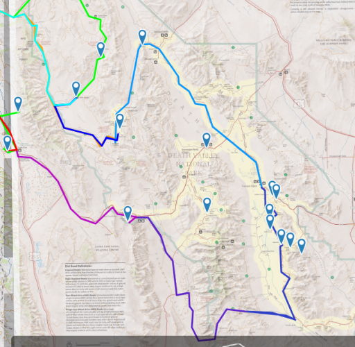
hey everyone. im coming from an advrider background and looking for some new stomping grounds. im looking to set up a trip to death valley in late march/early april and im looking for route advice and hopefully to find a few other people who might want to go with (should this be moved to west?). the basic idea is first day is saline valley road to the hot springs for camp. second day would be race track, teat kettle junction, ubehebe crater, and some where to camp. third day bad water, arsonist palette, west side road, maybe mangel pass and baker ranch. this is just a rough idea and im pretty flexable on the route. i originally was thinking of doing this solo with my dad and my girlfriend but dad wasnt keen on the idea of solo off-road travel. i will be in a 99 4runner with the basic mods and most the roads are pretty easy or can be gone around (main spots i know of is lippincott and mangle, but anyone with current road conditions would be great). i know this isnt the biggest time notice but fingers crossed ill make it work. below is an idea of about the first two days (first day will probably be a half day).

https://www.google.com/maps/dir/37.1735279,-118.2860307/Saline+Valley+Warm+Springs,+Death+Valley+National+Park,+DEATH+VALLEY,+CA/37.0130791,-117.4582533/@36.9147497,-117.848677,11z/data=!4m15!4m14!1m0!1m10!1m1!1s0x80bf718a274ebd27:0x6e2995c75b7be5a!2m2!1d-117.7661246!2d36.8128786!3m4!1m2!1d-117.5006498!2d36.8746438!3s0x80bf4108d6fbc54b:0x498fce4172a98730!1m0!3e0


Luinil Explorations

Rank VI
Launch Member

Influencer I

3,231
Wherever I am at the moment
First Name
Larrie is
Last Name
sharing our travels with the world.
Member #

19319

Ham/GMRS Callsign
KG7WDX
We did a similar trip in March of last year. Roads were in great shape. The road to the Racetrack is 20 miles of washboard. I was in a 04 Runner and it did great. It may be pretty windy. We had a dust storm that blew through camp. Make sure you have everything put away or tied down before turning in for the night. The link in my signature will lead you to the trip report. Hope you have a good journey.
 
  • Like
Reactions: TerryD

Enthusiast I

269
Brentwood, CA
Member #

3431

hey everyone. im coming from an advrider background and looking for some new stomping grounds. im looking to set up a trip to death valley in late march/early april and im looking for route advice and hopefully to find a few other people who might want to go with (should this be moved to west?). the basic idea is first day is saline valley road to the hot springs for camp. second day would be race track, teat kettle junction, ubehebe crater, and some where to camp. third day bad water, arsonist palette, west side road, maybe mangel pass and baker ranch. this is just a rough idea and im pretty flexable on the route. i originally was thinking of doing this solo with my dad and my girlfriend but dad wasnt keen on the idea of solo off-road travel. i will be in a 99 4runner with the basic mods and most the roads are pretty easy or can be gone around (main spots i know of is lippincott and mangle, but anyone with current road conditions would be great). i know this isnt the biggest time notice but fingers crossed ill make it work. below is an idea of about the first two days (first day will probably be a half day).

https://www.google.com/maps/dir/37.1735279,-118.2860307/Saline+Valley+Warm+Springs,+Death+Valley+National+Park,+DEATH+VALLEY,+CA/37.0130791,-117.4582533/@36.9147497,-117.848677,11z/data=!4m15!4m14!1m0!1m10!1m1!1s0x80bf718a274ebd27:0x6e2995c75b7be5a!2m2!1d-117.7661246!2d36.8128786!3m4!1m2!1d-117.5006498!2d36.8746438!3s0x80bf4108d6fbc54b:0x498fce4172a98730!1m0!3e0

My wife and I are planning to go there in late March. We weren't going to go as far south as you, though. After Racetrack we were thinking about doing Titus Canyon.

Sent from my SAMSUNG-SM-G890A using OB Talk mobile app
 

punk

Rank 0

Traveler I

Luinil, thanks for the heads up. I've ridden bikes there twice before and got a dust storm as we where leaving once, pretty crazy.

James, like I said, routes not set in stone so if your looking for fellow travelers cool, but if your looking for a nice weekend way with the wife I totally get it. I feel like I may have to post this in west to get more locals involved.
 

Crispy

Rank VI
Launch Member

Influencer II

3,921
Redmond, OR, USA
First Name
Nick
Last Name
Crisp
Member #

1158

upload_2018-3-19_7-45-33.png

I had planned on going March 29th- April 2nd. You may want to share the dates you plan on being there. I had originally planned on going to Alabama Hills Thursday night and then to Panamint Valley with a stop at Darwin Falls and Ballarat Ghost town before finding camp in Warm Springs Canyon on Friday. Then I was going to make my way North and stop for a few pictures on the way to Furnace Creek to gas back up and make camp South of the racetrack or Lower Springs which would take us down Lippincott.

But I may reverse the route and scratch Warm Springs Canyon so I can camp at Alabama Hills for the last two days. If I do this, I may go straight to Eureka Dunes for the first night, and head over Steel Pass to the hot springs and go up to the Racetrack via Lippincott and dry camp there for the second night. Then go to the crater and loop around south and take 190 back to Lone Pine to go to 'Bama.
 

Crispy

Rank VI
Launch Member

Influencer II

3,921
Redmond, OR, USA
First Name
Nick
Last Name
Crisp
Member #

1158

Hi @punk and @NorCalCrisp . My father, myself and my son will be in DV starting this this Saturday through next Saturday (23rd March to 29 March) doing the back country thing. You can see my planned route and just planning in general in my thread "Overland Alzheimer's: Death Valley"
I was following your thread. You have a great plan laid out. You may want to stop at lower springs for a dip in the hot springs on day 2. If there's a spot to camp, I'd recommend staying there for a relaxing evening since you will have plenty of time on day 3 to get to Racetrack and Teakettle junction. You also mentioned you'll be there from Saturday to Saturday, but the dates you mention is Friday the 23rd for day 1 and you have 5 days planned so looks like you have a couple buffer days. My original plan would have us overlapping at Darwin Falls so if I stick to that, I'll keep my eyes open for you and say hello. Or if I do end at Alabama Hills my last couple days, you should join up with us. We will be doing some night photography out there with views of Mt. Whitney. Looks like you enjoy photography, so the more the merrier.

EDIT: OH... I just realized you'd be leaving around my day 1 or day 2. lol. So if I stick to my original plan, we could meet at Alabama Hills. Ha ha ha.
 

Etoimos

Rank V
Launch Member

Member III

2,779
Peyton, CO
First Name
Keith
Last Name
Upton
Member #

11810

Yeah, the kid and I don't have to be back until the 1st. My dad is retired, but I thing his wife wants him home sooner. We'll see how it goes the last couple of days. lol

We'll check out the springs for sure. I'd love to got to the Alabama Hills to do some photography, but I don't think it will happen this trip. My father in law is does photography as well, and we have already talked about just doing a photo trip out there. I'm thinking maybe Oct if the wife does not shoot me for doing two week long trips without her :openmouth:
 
  • Like
Reactions: Crispy

punk

Rank 0

Traveler I

Sorry I haven't checked this in a while, kinda lost hope for a bit. The trip will be the 7-9 for us, and I'm still open to others joining in. Seeing as you guys will be out there the week before, updates on road conditions would be great. I'll try to post up more info when I get home.
 
  • Like
Reactions: TerryD

Sgt12XU

Rank V
Launch Member

Member III

2,306
Sunnyvale, CA
Member #

9241

Another overlander told me Wildrose Road is closed. They got past the first gate, but had to turn around at the second gate which cost them three hours of wasted time and frustration. This impacts the trip route. I think the canyn section of the road is closed, so we can't go from the Wildrose campground through the canyon to the Ballarat ghost town. We should call the park to clarify this.

https://www.nps.gov/deva/planyourvisit/conditions.htm
 
Last edited:

punk

Rank 0

Traveler I

Thanks for the heads up, there seams like a few groups will be posting up reports on their trips soon and might give an idea of road condtions as well. Will definitely look into it, worse come to worse well be stopping by a ranger station by that part of the trip and can ask about it. Only reason I'm even heading that way is to stop at Ballarat and show the gf mansons truck and the two loonys that hold that place together.
 

Enthusiast I

269
Brentwood, CA
Member #

3431

Farther north, but Saline Valley Road is in good shape the entire length, just lots of washboard. Lippincott Mine Road was good. I never even shifted the transfer case. The road to Saline Valley Warm Springs is excellent. I was on them yesterday.

Sent from my SAMSUNG-SM-G890A using OB Talk mobile app
 
  • Like
Reactions: punk

levelseventysix

Rank II
Launch Member

Contributor III

365
Oakland, California
Member #

11485

New to the group and new to overlanding. DV has been a place I've always wanted to visit. @MEU(SOC) I see you're in NorCal. I live in Oakland. What is the drive down to DV like? How much could one experience from the 7th-9th? I may be interested if I can move some things around at work.

I'd also have to make sure I have the proper camping gear. Still accumulating some things. But my jeep is outfitted.
 

Sgt12XU

Rank V
Launch Member

Member III

2,306
Sunnyvale, CA
Member #

9241

New to the group and new to overlanding. DV has been a place I've always wanted to visit. @MEU(SOC) I see you're in NorCal. I live in Oakland. What is the drive down to DV like? How much could one experience from the 7th-9th? I may be interested if I can move some things around at work.

I'd also have to make sure I have the proper camping gear. Still accumulating some things. But my jeep is outfitted.
@levelseventysix from Oakland it's a seven hour drive to Big Pine, which is our starting point. Unfortunately, we can't cut across the Sierras right now due all East/West cross over roads being closed for the winter. Suck. So, we have to all the way around the Sierras. We could go 580E to 5N to 88E to 395S. Google Maps says its 6 he 45 min that route. Or, we could go 101S to 152E to 5S to 46E to 99S to 178E to 395N (7 hr 15 min route). If we go over 88E, we need to really watch the weather since a snow storm could really delay or stop us. Currently no road restrictions on 88. If we go down 5S, weather is not a concern at all.

To check Highway road conditions:
http://www.dot.ca.gov/cgi-bin/roads.cgi?

Regardless, we all need to have extra gas cans and water for the trip. Some of us have good recovery gear, on-board air, and great camping gear. As a group, I think we'll be solid. I'm going to work on creating a trip route, similar to what @punk did in Google Maps but in an actual .gpx (or .kml) files. The last southern leg of punk's trip route is a no go due to Wildrose Road being closed. So, we need to change it up a little. I need to do more research. Never been to DV, just watched a lot of vids and read stuff online.