Influencer I
- 2,358
- First Name
- Dillon
- Last Name
- Wilke
- Member #
-
20298
- Ham/GMRS Callsign
- KJ7LVO/ WRQL275
- Service Branch
- USAF
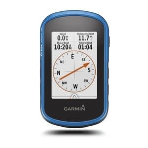
So Im looking for a set up that will not only work in my car, but also for hiking and biking, so we are talking handheld essentially. What are some of the best options? My chief requirements will be durability, weather resistance, and quality of antennae (speed of acquisition is nice, but more Im looking for the ability to keep a signal with cloud or tree cover).
Also to add, the ability to upload maps is nice but really not required. Im not an epic adventure type so the maps I would need to upload would be smallish, maybe a 100 mile area. Im a fan of paper maps so really to me GPS is just a tool to locate my position on a map faster. I can triangulate with a compass but Im lazy, lol.
Also to add, the ability to upload maps is nice but really not required. Im not an epic adventure type so the maps I would need to upload would be smallish, maybe a 100 mile area. Im a fan of paper maps so really to me GPS is just a tool to locate my position on a map faster. I can triangulate with a compass but Im lazy, lol.