Two friends and I are doing a day trip to the Stanislaus National Forest off of highway 4 on Saturday 4/28. Our general plan is to run the Sourgrass Trail and then if time allows to explore Board's Crossing, Calaveras Big Trees, and other dirt roads in the area. Or, we could go farther up 4 and do some snow wheeling. We would be happy to have some other OB members join up if anybody is interested in a trip.
Where
The Sourgrass Trail (05N02R Pine Needle Flat Road) is located south of highway 4 near Dorrington CA. It starts at the Sourgrass Recreation Area and follows the North Fork of the Stanislaus River for about 2.5 miles to where the trail ends at a nice campsite.
Here's a map of the area
When
Final times are still to be determined. But in general the plan is to arrive at the Sourgrass Day Use area sometime between 11 and 11:30. I am leaving the Walnut Creek area about 8:15 and plan to meet one friend at Brentwood about 9am. We will be meeting the other friend somewhere in Stockton or Angels Camp on the way up the hill. The Sourgrass trail takes 2-3 hours to run, and afterwards there is more to explore in the area.
Difficulty
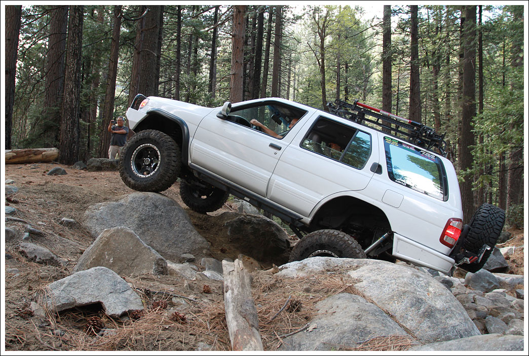
This is not a very difficult trail, but it is also not a flat dirt road and there is some risk of vehicle damage if drivers are reckless or don't pay attention to their spotter. For reference, one of my friends is new to offroading and is looking to work on his skills, the other is highly experienced and is going to test out some new modifications to his truck. This is a good trail for starting to learn some rockcrawling skills.
I would rate this trail a 4/10 in terms of difficulty. There are some reasonable sized rocks, a water crossing, and a steep climb. I have seen stock XTerras go through this trail before with no issues. That said, it is still very early in the season and sections of the trail could be eroded or muddy which would make it more difficult. There is one short climb that is often difficult for non-locked IFS trucks, so we will quite likely get to break out the recovery strap or winch.
More trail information and pictures. If you do a Google image search for "Sourgrass Trail" the first couple of pictures with very large rocks are NOT this trail, those are the Slickrock trail and somehow got mislabeled.
https://www.fs.usda.gov/recarea/stanislaus/recarea/?recid=14875
http://www.4crawler.com/4x4/CA-4/index.shtml
http://www.blankwhitepage.com/gallery/sourgrass_20050612
http://www.blankwhitepage.com/gallery/sourgrass20040524
Recommendations
To keep things moving and to prevent us from blocking the trail let's limit the group to 8 rigs or less. Sign up below if you are interested, and of course post if you have any questions.
1. Matt (4Runner)
2. James (Tacoma)
3. Dean (Pathfinder)
4.
5.
6.
7.
8.
Where
The Sourgrass Trail (05N02R Pine Needle Flat Road) is located south of highway 4 near Dorrington CA. It starts at the Sourgrass Recreation Area and follows the North Fork of the Stanislaus River for about 2.5 miles to where the trail ends at a nice campsite.
Here's a map of the area
When
Final times are still to be determined. But in general the plan is to arrive at the Sourgrass Day Use area sometime between 11 and 11:30. I am leaving the Walnut Creek area about 8:15 and plan to meet one friend at Brentwood about 9am. We will be meeting the other friend somewhere in Stockton or Angels Camp on the way up the hill. The Sourgrass trail takes 2-3 hours to run, and afterwards there is more to explore in the area.
Difficulty
This is not a very difficult trail, but it is also not a flat dirt road and there is some risk of vehicle damage if drivers are reckless or don't pay attention to their spotter. For reference, one of my friends is new to offroading and is looking to work on his skills, the other is highly experienced and is going to test out some new modifications to his truck. This is a good trail for starting to learn some rockcrawling skills.
I would rate this trail a 4/10 in terms of difficulty. There are some reasonable sized rocks, a water crossing, and a steep climb. I have seen stock XTerras go through this trail before with no issues. That said, it is still very early in the season and sections of the trail could be eroded or muddy which would make it more difficult. There is one short climb that is often difficult for non-locked IFS trucks, so we will quite likely get to break out the recovery strap or winch.
More trail information and pictures. If you do a Google image search for "Sourgrass Trail" the first couple of pictures with very large rocks are NOT this trail, those are the Slickrock trail and somehow got mislabeled.
https://www.fs.usda.gov/recarea/stanislaus/recarea/?recid=14875
http://www.4crawler.com/4x4/CA-4/index.shtml
http://www.blankwhitepage.com/gallery/sourgrass_20050612
http://www.blankwhitepage.com/gallery/sourgrass20040524
Recommendations
- Rock sliders are not strictly necessary, but there are some rocks big enough to cause damage if you are not careful.
- Functional spare tire, make sure it has air.
- Clothes for weather ranging from 70+ and warm to cold and rainy.
- Gloves and boots in case it is muddy.
- FRS/GMRS radio for communication.
- This is a family friendly trip.
- Nobody gets left behind, we all share responsibility for making sure everybody gets back to the highway.
- If the trail turns out to be very wet we will turn around if there is any risk of causing damage to the trail.
- Everybody accepts sole responsible for the safety of their vehicle and its occupants.
- All vehicles must have solid front and rear recovery points.
- Have fun!
To keep things moving and to prevent us from blocking the trail let's limit the group to 8 rigs or less. Sign up below if you are interested, and of course post if you have any questions.
1. Matt (4Runner)
2. James (Tacoma)
3. Dean (Pathfinder)
4.
5.
6.
7.
8.